...from near the end of May to a bit past the middle of June and I've been engrossed in studying up and prepping for a good many weeks now. It's an ecotour factory standard schedule:
- Anchorage
- Nome and the Seward Peninsula
- Anchorage
- Denali
- Anchorage
- Seward and on the boat to Northwestern Fjord in Kenai Fjords National Park
- Anchorage
Then we'll hang out in Anchorage for several days after the tour's history.
Alaskan geography has always been a vague blur to me and I've spent weeks exploring on Google Earth, punching coordinates into the Garmin 3590, learning strange corrupted native Alaskan names, getting feels for mountain ranges and drainages, delving into a bit of history, acquiring and organizing gear.
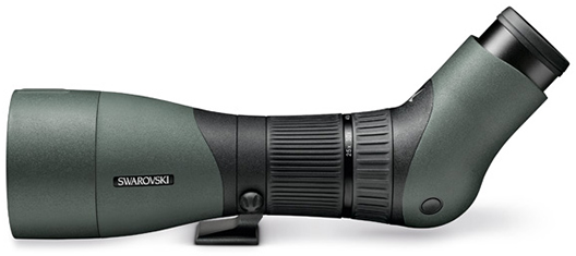
I've never had a serious spotting scope before and have lately been doing pretty well with my stabilized 10x42 Canon. But we're gonna be dealing with open tundra and lotsa ocean where power is definitely gonna be the name of the game.
I'm feeling really queasy about the expenditure but it's likely to make the difference between crap and high quality sightings of some spectacular once-in-a-lifetime critters and I'm hoping the rest of the group will greatly benefit from having it along.
Sister - who decades ago spent a lot of time in Anchorage working for an environmental center - just came back east to visit both brothers and single daughter. Yours Truly was second half of Monday through early Wednesday. Tuesday we rolled to the Eastern Shore's Blackwater National Wildlife Refuge - where I hadn't been for a million years. Wanted to see the birds and seriously field test the scope.
Sky was clear and there were lotsa great birds around but there was a vicious frigid nor'easter blasting and the first effort with the scope didn't go all that well. I was pleasantly surprised that the tripod stayed up just fine even with no scope on it but a really couldn't see shit 'cause my eyes were tearing up. And the wind chill was getting to me fast despite lotsa layers.
But we were eventually able to position ourselves in the lee of a forested section and put the scope through some paces on a thick flock of Snow (and Blue) Geese and other waterfowl. The angled eyepiece makes it pretty easy to accommodate people of varying altitudes and aim at stuff well above the horizon but rain and car window mounts are a good bit more problematic than they are with straight shooters. But you can get around those issues reasonably well by rotating the scope ninety degrees such that the angle lies in a horizontal plane.
Snow (and Blue) and Canada Geese, Tundra Swans, Mallards, Black Duck, Shoveler, Teal, Coot, Pied-Billed Grebes, Great Blue Herons, Terns, Eagles nesting in surprisingly close proximity to other pairs. And got a beautiful little male Kestrel on a wire on the way in.
Been having some health problems lately. Not really serious but not all that goddam unserious either.
Did that major nosebleed at the Vegas airport 2018/01/09. Assumed that I was ODed on Warfarin and adjusted dosage accordingly. But the test when back at the clinic indicated otherwise. So I resumed what I'd been doing before and next tested at 3.2. Supposed to hit between 2.0 and 3.0 but doc and me both felt close enough. Then on 2018/03/01 I had a twelve hour bleed that put me close to blackout. After that found that if I frequently/obsessively shoved Vaseline up my nose I'd be in good shape. But apparently a long night's sleep derailed me and on 2018/03/09 I bled heavily for fourteen hours after a trigger of the Vaseline application and was prepping for the emergency room before I got it stopped. Can't begin to describe what a miserable experience that was.
Adjusted down again and got extra anal on the Vaseline. Another bleed this morning triggered again by the application - gentle as it was - that scared the crap outta me but got it stopped in reasonably short order. Yesterday I was really down with some nasty flu thing, fever up to 100.5, eased off on the Vaseline 'cause I was too sick to do much beyond cowering under covers.
I think I've got an issue with a paper thin left nostril membrane that's having trouble healing properly but that I should be OK if I keep my INR in the lower end of the desired range, go really nuts with the Vaseline, and carry some Vitamin K1 doses which kick in clotting responses. I don't even wanna think about the consequences of another one of these way the fuck up in the middle of nowhere on the Seward Peninsula and I'm thankful that if I've gotta have problems I'm having them now.
Anyway... Alaskan wish list. Northern Shrike, Gyrfalcon, Trumpeter Swan, Puffins, Ptarmigan, Wolf, Grizzly, Musk Ox, Caribou, Dall Sheep, Humpback, Orca, Sea Otter, Denali summit offhand. I'm sure this will be greatly expanded as time goes on. And I sure hope that scope proves intrumental in nailing a couple of those.
Attempted Snake rescue today, but I was too late. He looked fine when I got to him and I was hoping that he was just cold, but no.
I figured that it would be a good idea to get him off the road so that the Turkey Vultures didn't go after him and end up getting hit by cars while feeding.
I picked him up just behind his head and was still half expecting to get a sudden fight of "Let go of me you asshole".
No. As I lifted this three footer I could feel his lifeless spine relaxing. It felt like I was feeling his death.
Yeah, I previously mentioned that in Belize I deliberately left a dead possum on a lightly traveled dirt road with dense vegetation on both sides so that the vultures could quickly and easily find it. And then the next morning I found a dead Black Vulture lying next to the dead possum. And I strongly suspect it was a deliberate hit.
...
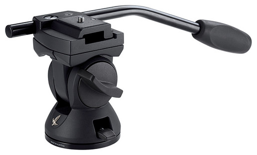
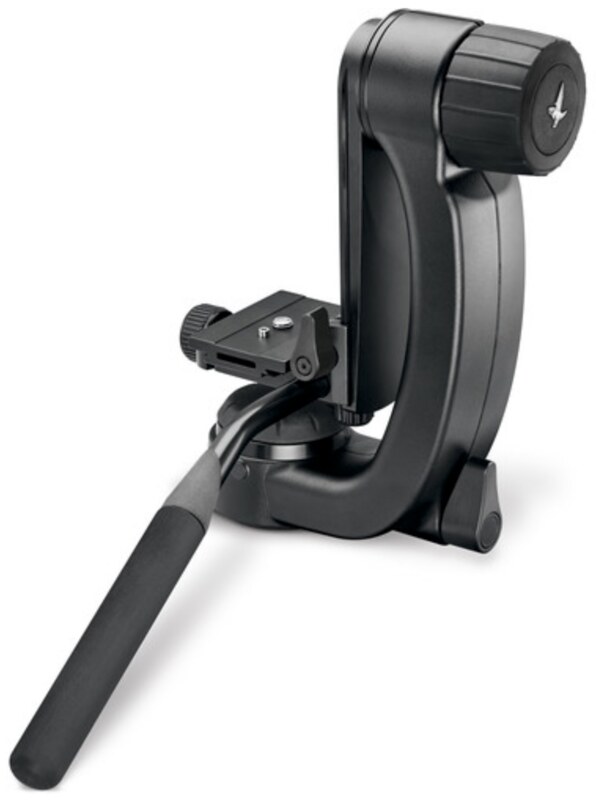
Got a Swarovski PTH tripod head:
Tuesday for the Alaska trip and have been setting it up with the tripod and scope to look through the back patio door at the feeders to practice aiming, focusing, working the controls. (There's lotsa skills involved with this that I don't have much of yet.) The male Goldfinches are now just about in full breeding plumage and really spectacular - hard to get tired of looking at them.
Thursday I had one on one of the thistle seed feeders and he was absolutely FROZEN in position - not so much as blinking. Checked out several others in the vicinity and ditto. I bent down and looked up into the canopy for a Cooper's Hawk but struck out. And then a first year male Cooper's Hawk suddenly appeared on a branch above the feeders.
I made a rule of ALWAYS checking the feeders before flying Quinn and ALWAYS stuck to it. But on the late morning of 08/01 of last year I was halfway down the exceptionally steep driveway with Quinn in hand ready for another training flight and remembered that I hadn't checked the feeders.
But then I said to myself... There haven't been any bandits around since her first flights in late spring, everything's always been fine at the feeders; she's in 99.9 percent full feather, has had a lot of free flight experience, is in excellent physical condition - and it's a long hard walk back up the driveway. Fuckit.
And then I never saw her again except in a few really disturbing dreams. I have her again, she's fine, this is too good to be true, must be a dream, wake up abruptly, poof.
It's hard to look at ANY bird now without thinking of her and hating myself for that ONE MOMENT of unforgiveable stupidity carelessness.
Sorry, not very soon. (Thirty days since my last post - a major Kite Strings record.) My expectations were that this would be a very punishing trip and they didn't fall the least bit short. Got back home latish Tuesday night exhausted and in pretty bad shape with a major lawn issue that needed dealing with early yesterday.
Internet access was mostly nonexistent to spotty. The schedule was packed and I never had zilch in the way of time and/or energy to spare.
Had about five pages worth of trip items inventory to organize, stow, carry, wear, check, keep track of totaling about seventy pounds but was in pretty good shape on the morning of 2018/05/30 and marveling that it was possible to hop an early afternoon plane for Seattle at BWI, change to another plane and airline late afternoon local, and arrive at Anchorage with over two and a half hours of the day left at destination. Then reality reared its ugly head.
HM's scheduling I'd always thought was a bit optimistic and I'd been substantially concerned about being able to get off of Southwest in Seattle, recovering checked baggage, rechecking baggage into Alaska Air, getting through security and to the gate on the next plane inside of a 2:20 window.
Then after Uber dropped us off there was a major delay on the board - as happens not infrequently when an airline has had half a day's worth of opportunity to fuck things up. The estimate kept fluctuating in and out of the range of hope for a while before we reached the obvious no-way-in-hell point and we were standing at the carousel waiting for our stuff to appear while Alaska 187 being backed away from its gate with a couple extra empty seats.
HM takes the next available single open seat, I do the following next available single on 735 leaving at 21:45. 30D - starboard aisle. So much for 30F on 187 at 18:55 where I'd planned on exploring the coast visually in daylight and navigating with my Garmin. "Bon voyage, make sure to turn your cell phone ON when you get there."
It's dark when we head out for the nearly fifteen hundred mile hop. But as it gets LATER (and we get farther north and west) it starts getting distinctly LIGHTER and I'm able to make out some terrain features here and there through what little I have in the way of window view.
Plane docks at 00:20 local - PDT minus one. Idiot Uber driver can't find the main entrance to the Puffin Inn but there are Puffin Inn signs all around and I check the near door on the building in front of me. It opens and the first door on the left is 1304 - our room number. Too easy! (Too easy.) OK, I'm good, thanks, bye.
Then I try the entrance door again and it's locked. OK, call HM. His fucking cell phone is OFF and I get his fucking recording. Then I call the graveyard shift total idiot at the desk and describe my situation and what I'm seeing.
"Oh, you're at our ANNEX. You need to go a half a block NORTH."
"I don't know which way north is. But I'm looking across the street at a Subway."
"I don't know where that is." (And I can't be bothered to find out and give you any actual help.)
"OK, I can probably use Waze and figure things out. Thanks." (For nothing you useless incompetent total moron.)
I light up Waze but it's hard to figure out direction unless you're moving. And I'm a total zombie at this point and need to move carrying everything I own at way less than very slow car speed. Could've dug out the Garmin and figured things out a lot easier but see above about being a total zombie at this point.
I can only move a few yards per effort and need long rest periods in between. It's dark and I'm cold, weak, vulnerable, and scared. I'd have been short work for a six-year-old with a sharp stick.
I think it took me an exhausting hour and a half to figure out which way was up and make it by the desk and into the room finally at about 03:45 AKDT or 2018/05/31 07:45 EDT. And I think it took me the better part of a week for my body and mind to rebound from the experience. (Hard to tell for sure though 'cause of all the other experiences with which I was continously being hammered.)
And when I reconstructed things I realized that all the stupid bitch at the desk needed to do when I told her I was looking across the street at a Subway was tell me to do an about-face and march a hundred yards - around the corner of the annex building and across the parking lot at which one Jaymes Bradley would be shot dead by one Orlando G. Holder 2018/06/14 21:30 on our second stay at the dive about fifty yards from where we were sitting in our Room 1115 on our second stay after the conclusion of the Naturalist Journeys tour and right after having returned from dinner.
Anyway... The trip, although majorly punishing, was an ASTOUNDING sensory overload experience and it's gonna be a major effort to report on it. And I've gotta take another break now to deal with a bit more real world stuff. But stay tuned.
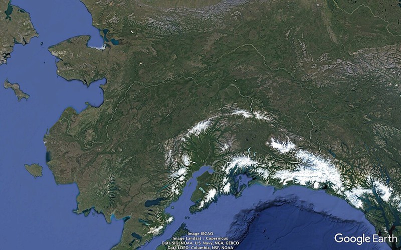
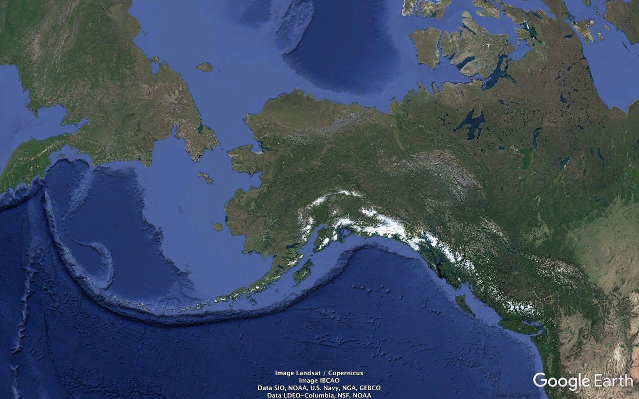
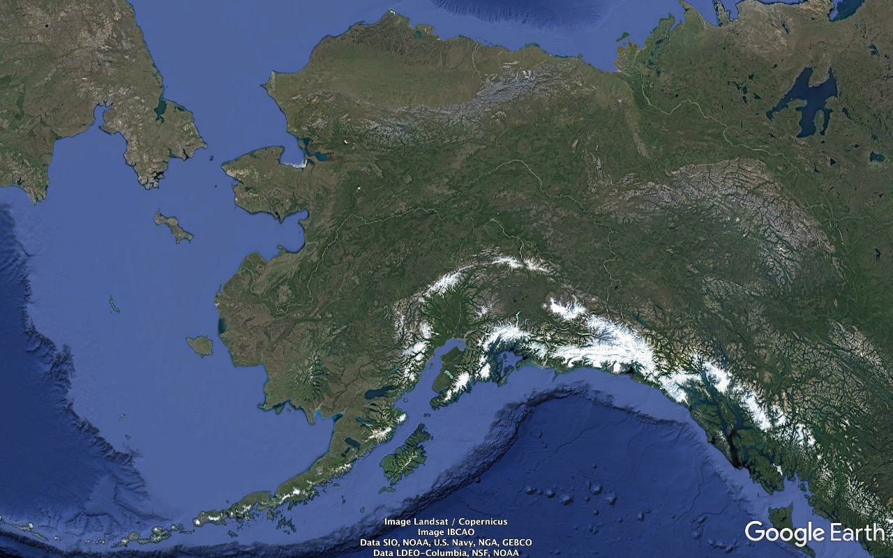
Prior to prepping for this trip I understood pretty much zilch about how our 49th state was put together, where things were, what they were named. Couldn't have pointed to stuff like the Seward Peninsula, Yukon River, Dutch Harbor, Kodiak Island, Seward, Prince William Sound. So I played with the trip itinerary, Google, Google Earth, Wikipedia, Alaska.org; memorized names mostly based on corrupted native designations, Russian, English; punched zillions of locations, coordinates into the GPS receiver and came up with a rough feel for which way was up.
So Alaska geography lesson (and, as always, the link above the image gets you full resolution)...
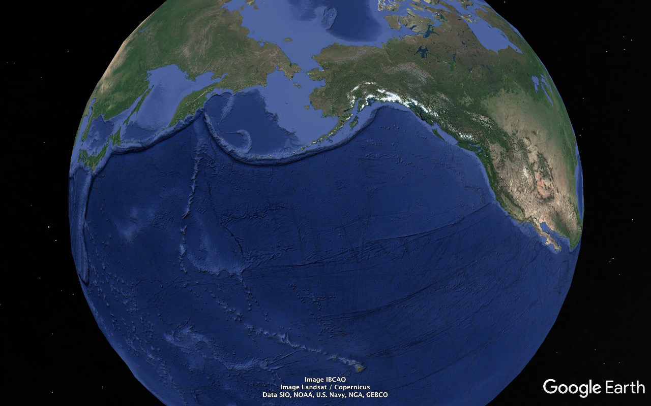
All that light blue stuff between North America and (Eur)Asia and in the vicinity is astoundingly shallow. At the Bering Strait Valley in the Bering Strait (the currently missing section of the Bering Land Bridge) depth maxes out at about 180 feet. Much of it's just a bit over a hundred.
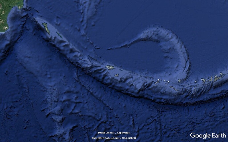
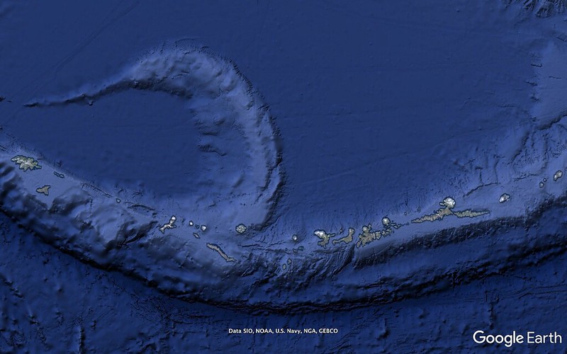
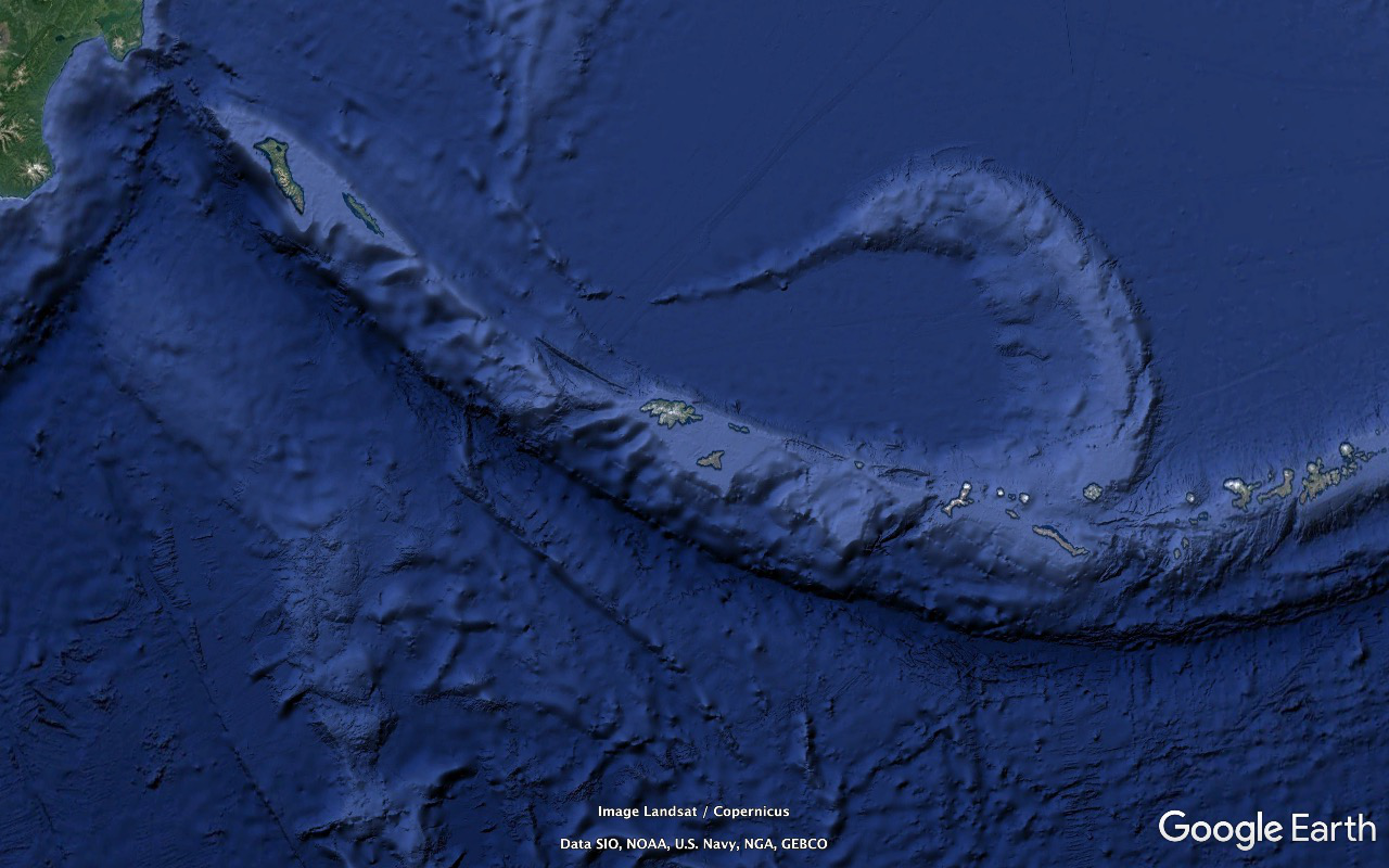
The (volcanic) Aleutian Islands extend off the Alaska Peninsula virtually all the way to the Kamchatka peninsula.
The Bering Sea is what's rimmed by the Bering Strait, Alaska, the Aleutians, Asia.
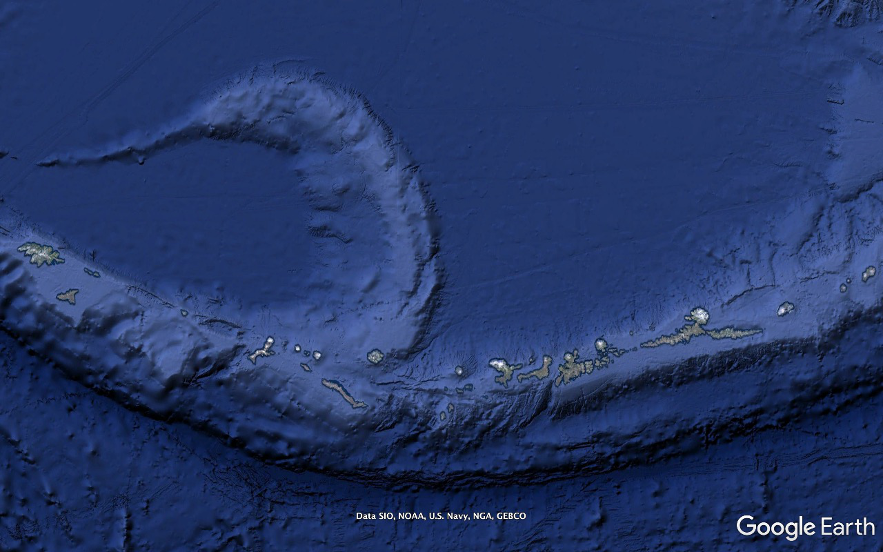
Those north/south aligned seamounts that virtually converge at the end of their range with the far end of the Aleutians are the far end remnants of the Hawaiian Islands chain.
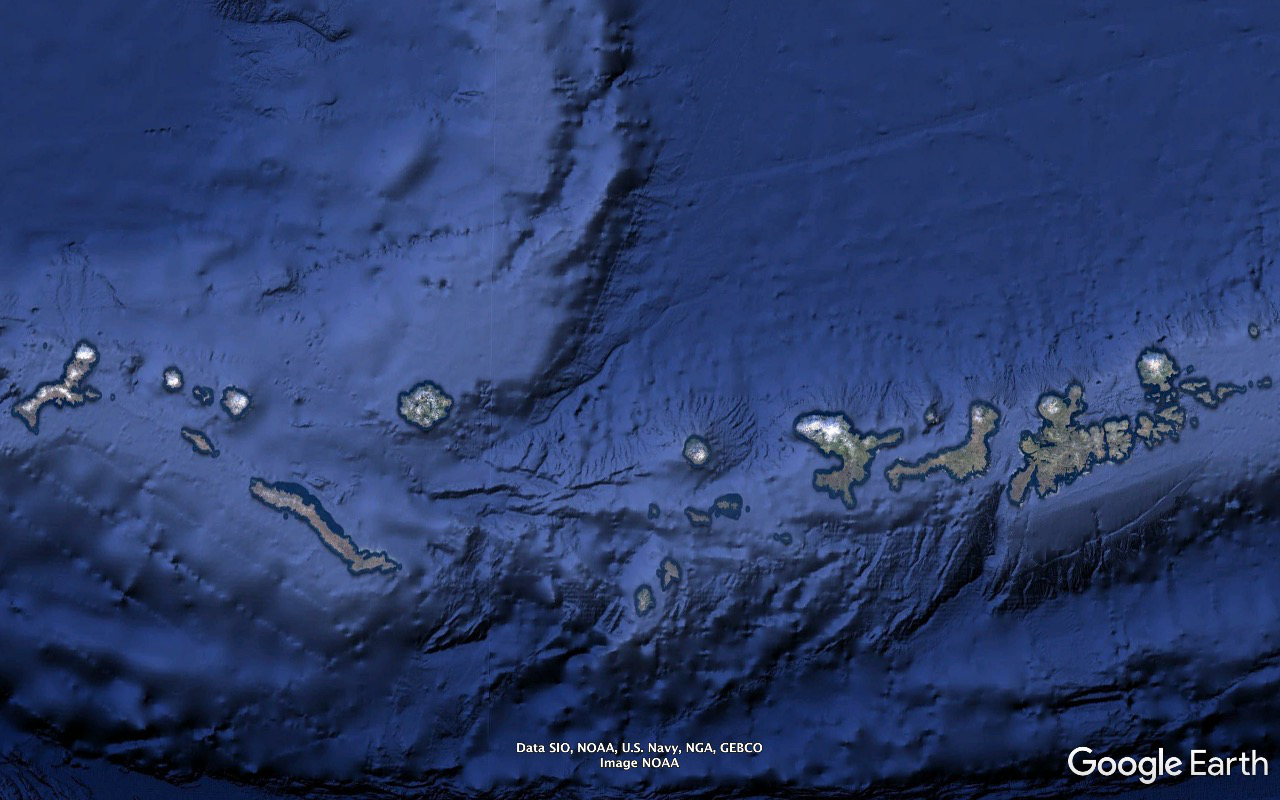
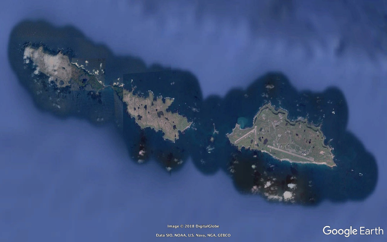
we go from the western half of the Andreanof (Andreyan Tolstykh) Islands group through Attu, the outermost US possession, to Czaasrly and Bering Islands, Russian possessions. A bit south of the midpoint of the former you're at the same latitude - 54°39'43.52" N - as the southernmost bit of the (southeast) Alaska Panhandle. Danish cartographer and explorer Vitus Jonassen Bering died on the latter 1741/12/19.
...the little rock in the bottom middle at 51°12'52.95" N 179°07'48.11" W in the (Eustrate Ivanovich) Delarof subgroup of the Andreanofs is the southernmost point of Alaska and is 18.12 miles south of the Royal Observatory Greenwich and a bit south of the M25 / London Orbital Motorway.
Amatignak also features the westernmost point of land on Alaska, the US, North America. You can get to about 179°08'50" West longitude. Next islands over are Semisopochnoi and Amchitka in the Rats group and Eastern Hemisphere.
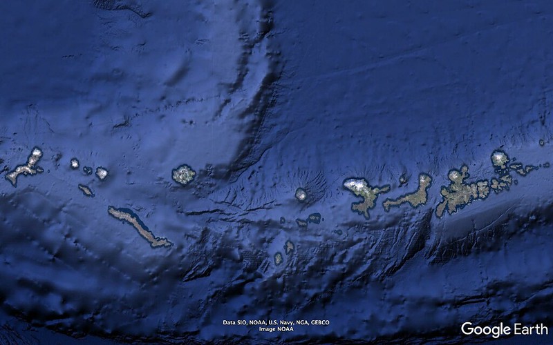
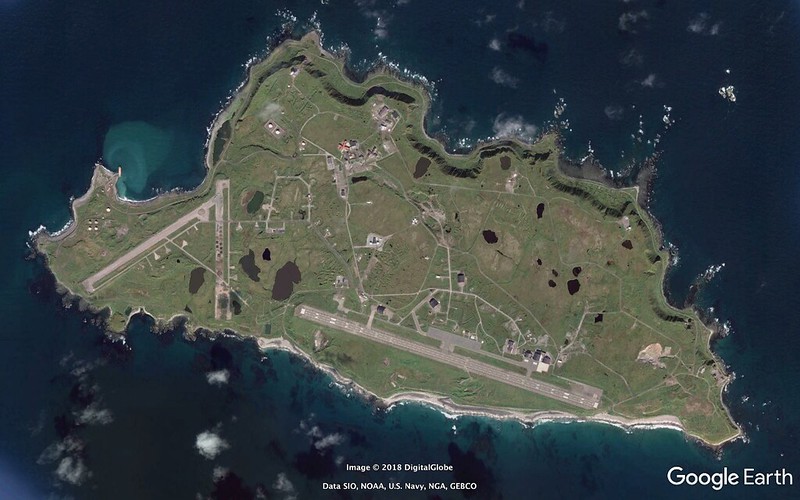
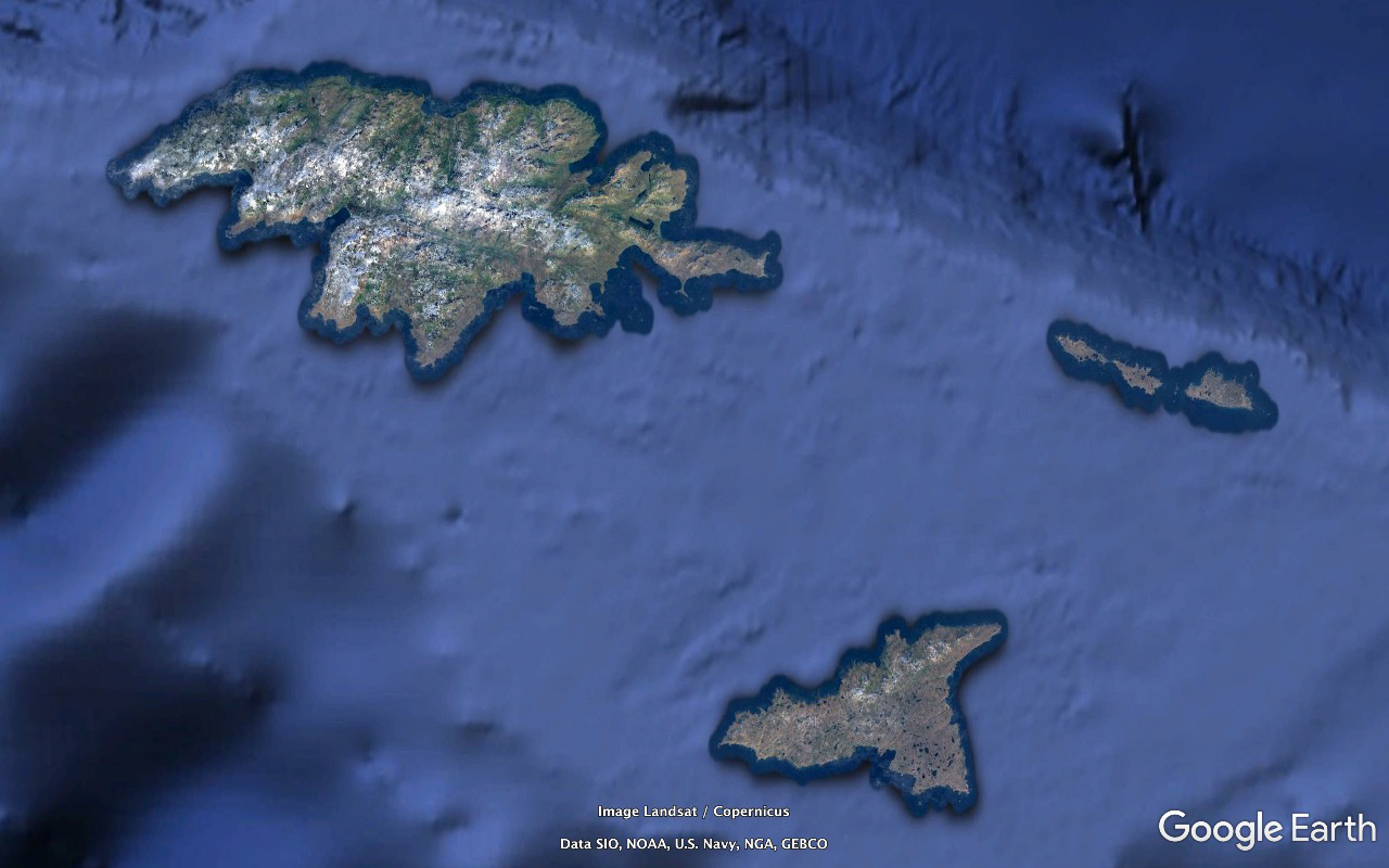
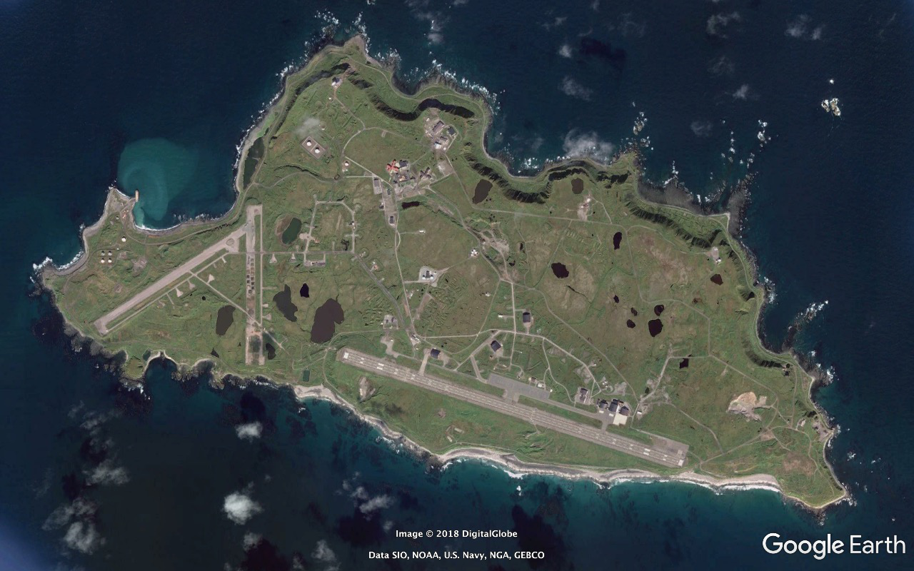
Close-up of the end of US turf, the Near Islands - clockwise from the top: Attu, Alaid, Nizki, Shemya, Agattu. Attu was occupied by the Japanese 1942/06/07 through 1943/05/30 - maybe some minor conflict into early July.
On 1993/04/06 it became Eareckson Air Station - after US Army Air Force Colonel William Olmstead Eareckson, an important figure in the Aleutians campaign. They flew my retired Navy Captain father out for the dedication ceremony. One of our group - a submariner - and an old Marine I bumped into at the motel in Seattle on the way home knew it and the story. The latter had been stationed there for quite some time.
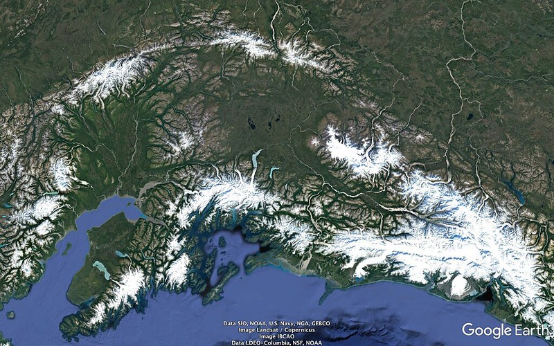
North of Alaska is the Beaufort Sea. North of the Bering Strait is the Chukchi Sea.
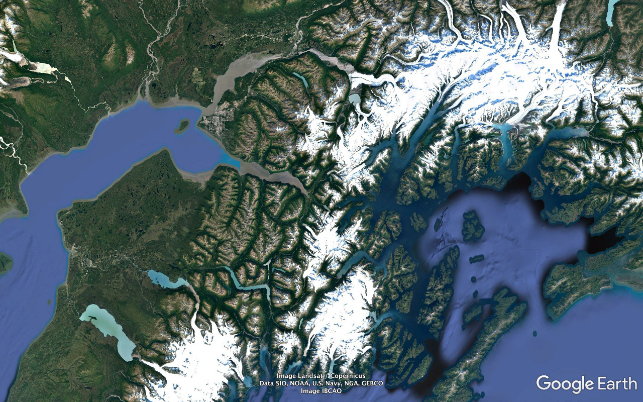
The Gulf of Alaska is defined by the continent in that neck of the woods, the Kenai Peninsula and Kodiak Archipelago, Alaska Peninsula and Aleutian Islands.
(Grigory) Shelikof Strait runs between the Alaska Peninsula and Kodiak Archipelago.
The (William Henry) Seward Peninsula extends out into the Bering Strait and was this end of the Bering Land Bridge.
(Otto von) Kotzebue Sound to its north and (Sir Fletcher) Norton Sound to its south.
The top end of British Columbia's Graham Island, the big chunk of land at the north end of the Haida Gwaii archipelago / Queen Charlotte Islands (and under the middle of "Google" in this frame) is an excellent marker for the southeast end of the Alaska Panhandle - the closest the state gets to the Contiguous 48.
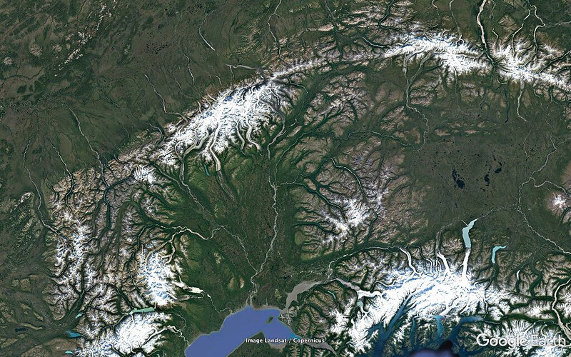
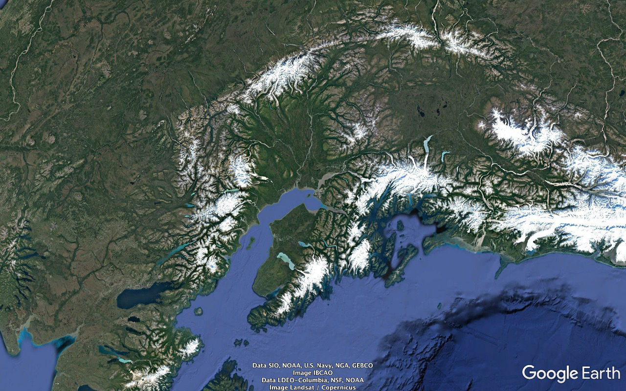
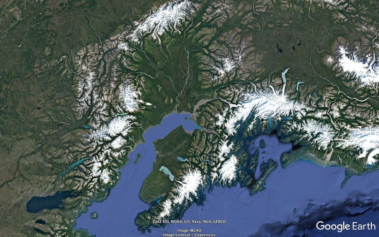
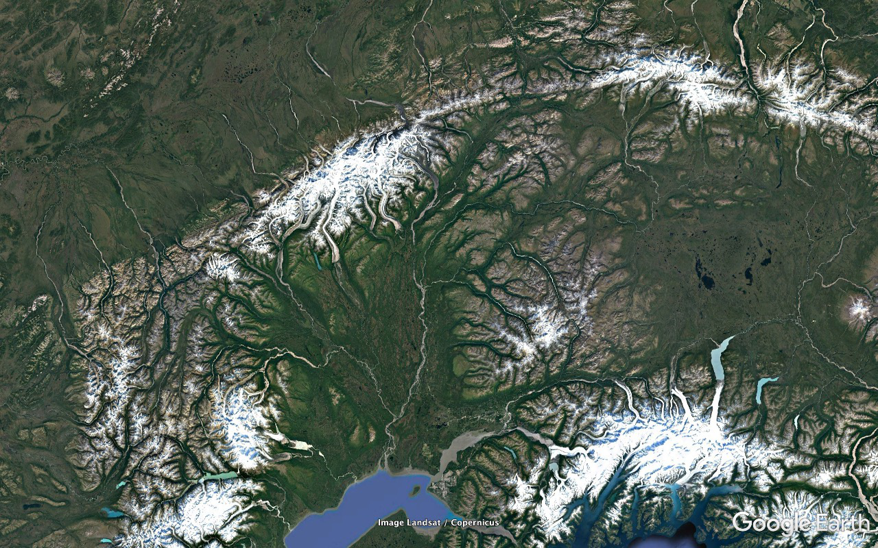
Mountain ranges:
- Alaska Range arcing across the top
- Talkeetna Mountains a bit to the east of being between the Alaska Range and Anchorage
- Wrangell Mountains south of the eastern end of the Alaska Range
- Chugach Mountains running west along the coast to Anchorage
- Kenai Mountains down the peninsula of the same name
- Aleutian Range running from south of the eastern end of the Alaska Range, down the Alaska Peninsula, and...
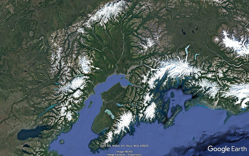
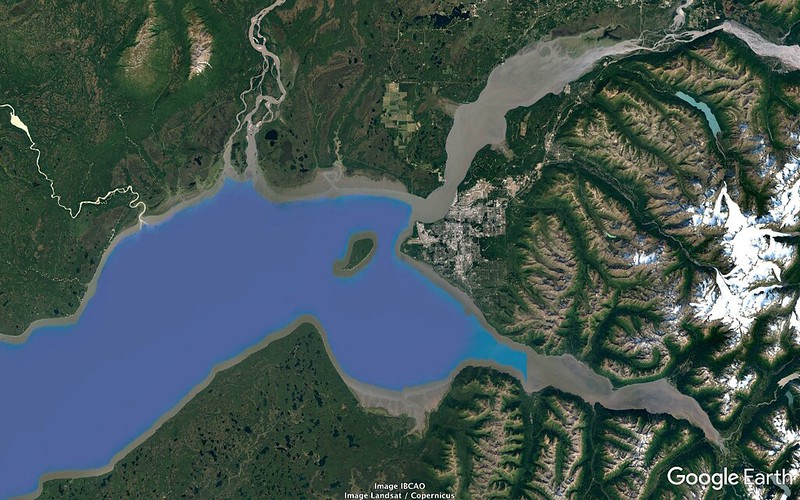
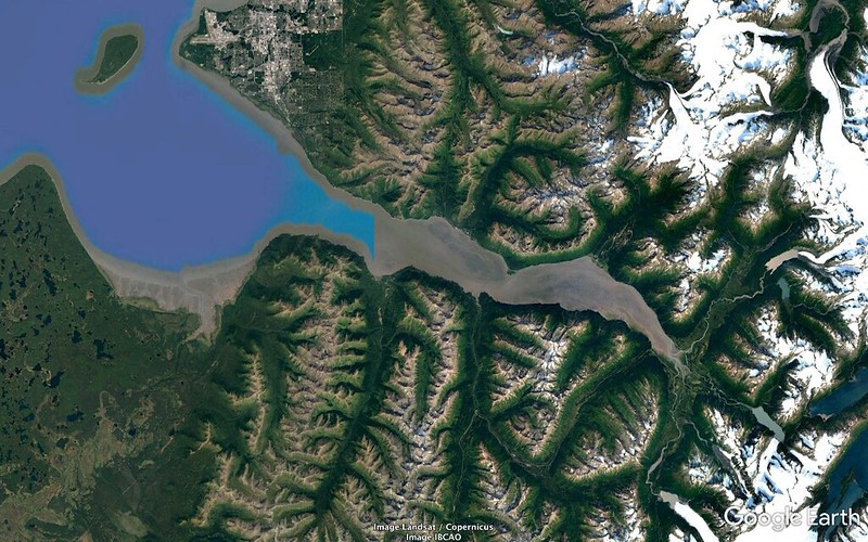
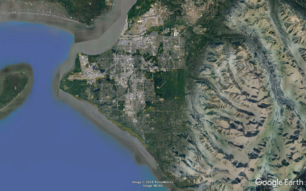
Cook Inlet separates the Kenai Peninsula and Anchorage area from the mainland.
The Susitna River drains from the north into the northern extremity of Cook Inlet.
Prince William Sound - as in the 1989/03/24 Exxon Valdez world class environmental disaster - is the mostly enclosed body of water to the west of Cook Inlet. The 1964/03/27 Good Friday Earthquake was epicentered at about 60°54'30" N 147°20'18" W, a little north of the Sound at its center at a depth of about fifteen and a half miles.
The Kenai Peninsula is the land mass SSW of the "isthmus" of terra firma between Prince William Sound and the east reaching Turnagain Arm extension of Cook Inlet.
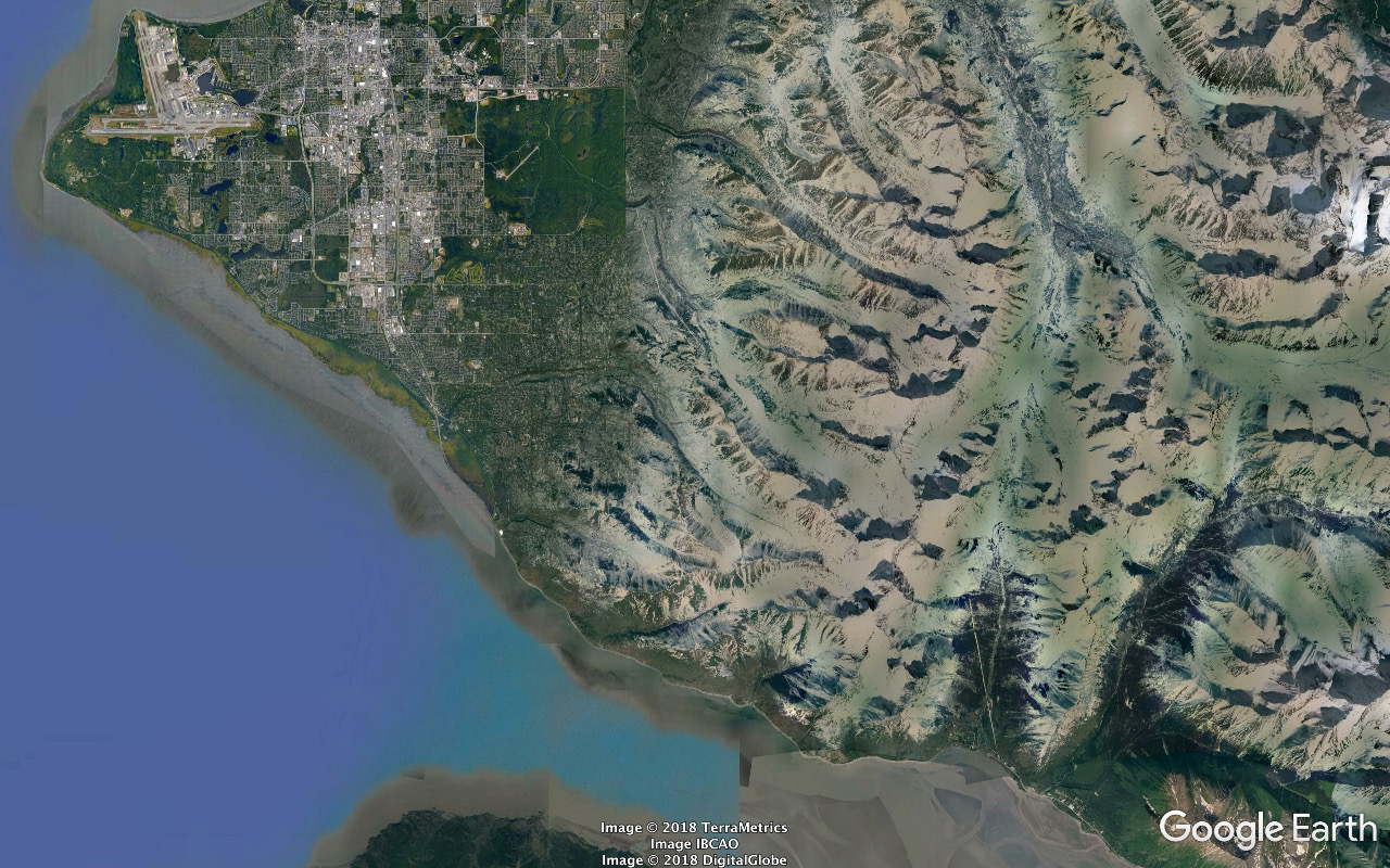
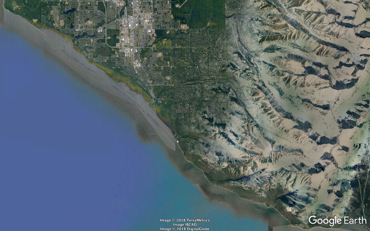
...Knik (NE) and Turnagain (ESE) Arms. This extremely obvious and mega-important peninsula has lacked a name until now so I'm giving it one - the Chugach Peninsula, effective 2018/07/21 22:40:00 UTC.
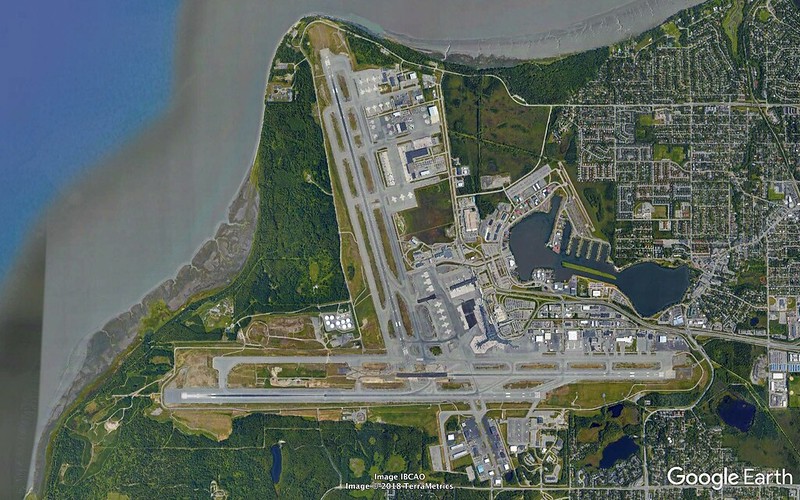
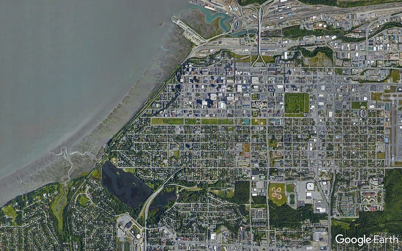
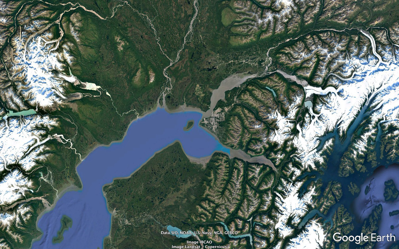
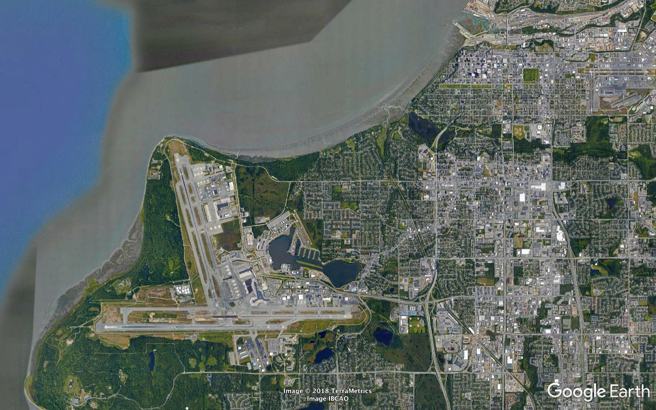
Point (Count Simon Romanovitch) Woronzof off the upwind end of Runway 33. Earthquake Park is the big forested half-circle of land the crumbled off its edge of the peninsula on 1964/03/27 and fell thirty feet. Note the similar pattern running on the edge ENE along the Knik Arm and east along Ship Creek.
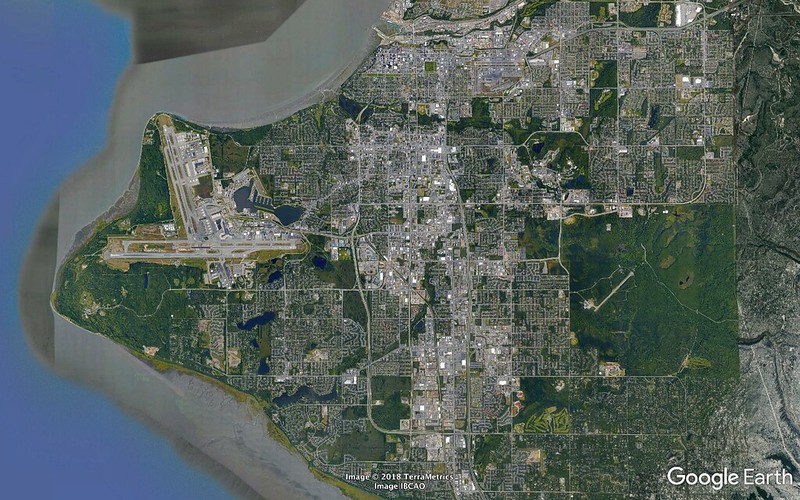
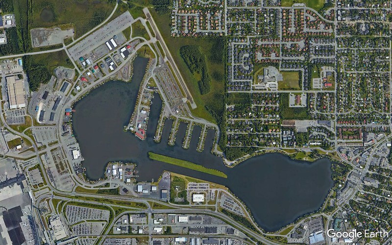
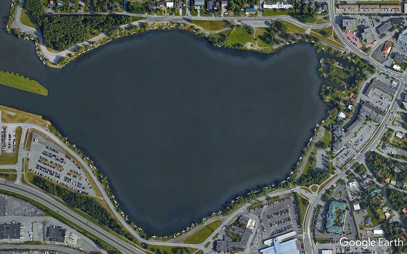
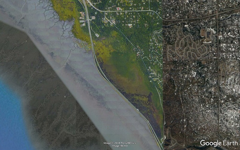
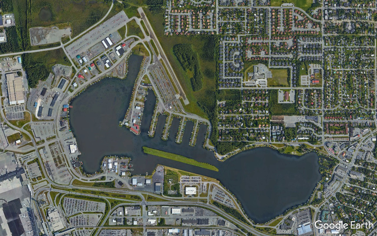
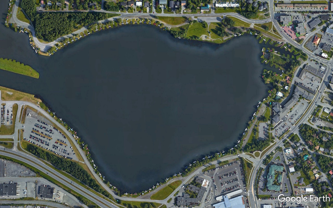
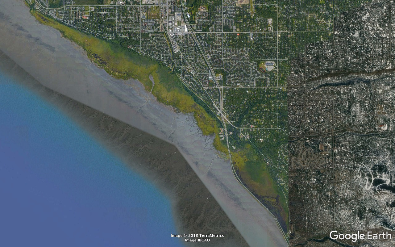
...and Lake Hood Seaplane Base - the world's busiest averaging about 190 flights per day. The Hood Canal was dredged out to connect Lakes Hood, west, and Spenard, east, and serve as a float plane runway. Planes take off and land on floats in the summer and skis in the winter and note the gravel strip for the wheels option. (The Puffin Inn complex occupies the little roads triangle enclosure just off Spenard's NE end.)
Note the planes ringing Lake Spenard at their coveted slips. (The (Millennium Hotels and Resorts) Lakefront Anchorage is the building complex at the east end of Spenard closest to the shore.)
Note the:
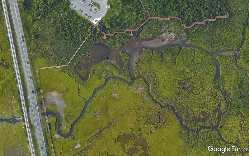
- (James) Delaney Park Strip. Started life as a firebreak and was soon recognized as nice place to land a plane.
- closer look at the northeastern run of The Crack. The Copper Whale Inn straddles the crack where its north/south aligned shortly before turning east for its run along Ship Creek.
Turnagain Arm was named by William Bligh of HMS Bounty fame. Bligh served as Cook's Sailing Master on his 3rd and final voyage, the aim of which was discovery of the Northwest Passage. Upon reaching the head of Cook Inlet in 1778, Bligh was of the opinion that both Knik Arm and Turnagain Arm were the mouths of rivers and not the opening to the Northwest Passage. Under Cook's orders Bligh organized a party to travel up Knik Arm, which quickly returned to report Knik Arm indeed led only to a river.
Afterwards a second party was dispatched up Turnagain Arm and it too returned to report only a river lay ahead. As a result of this frustration the second body of water was given the disingenuous name "Turn Again".
Largest tides, up to forty feet, in the US and third largest in North America - after the Bay of Fundy and Ungava Bay, which tie for first.
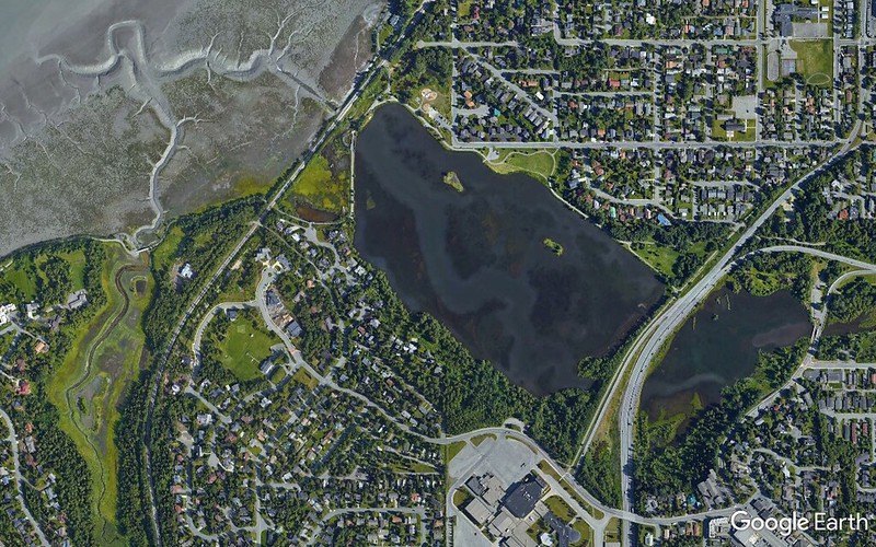
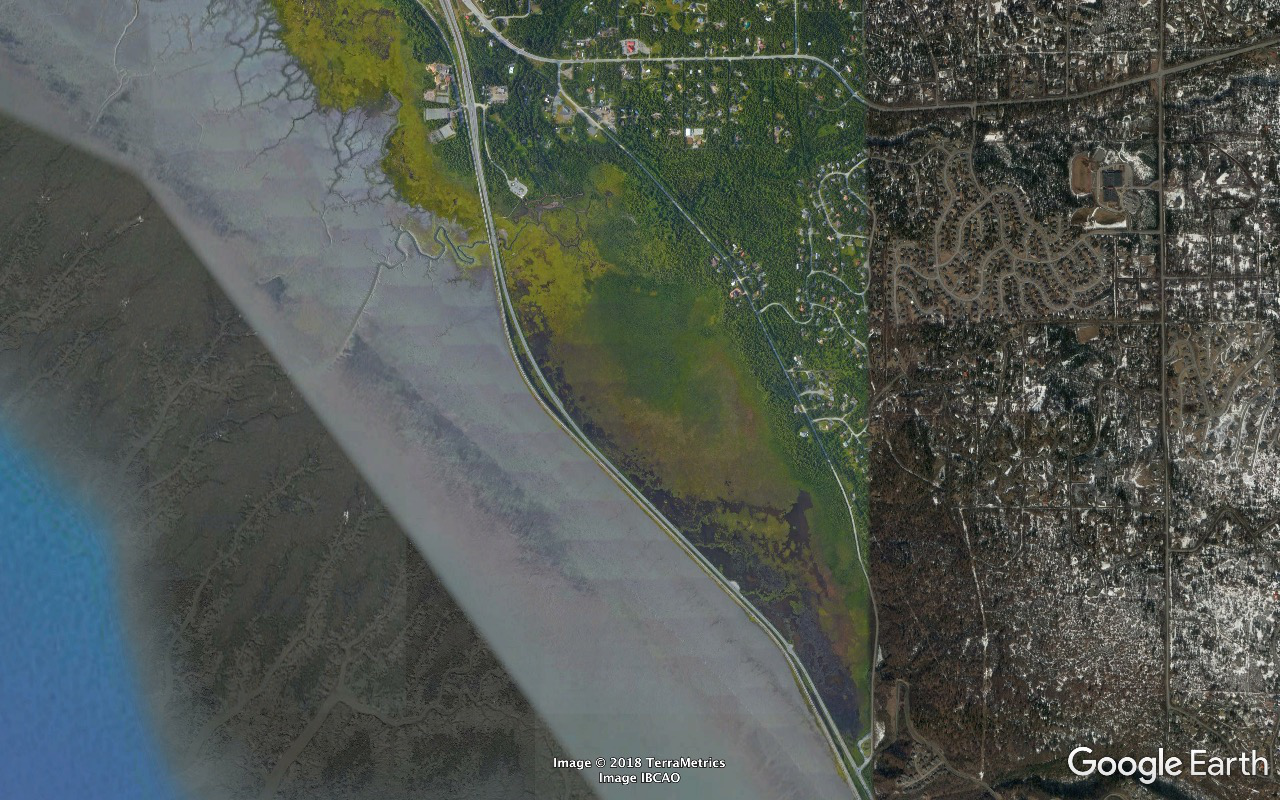
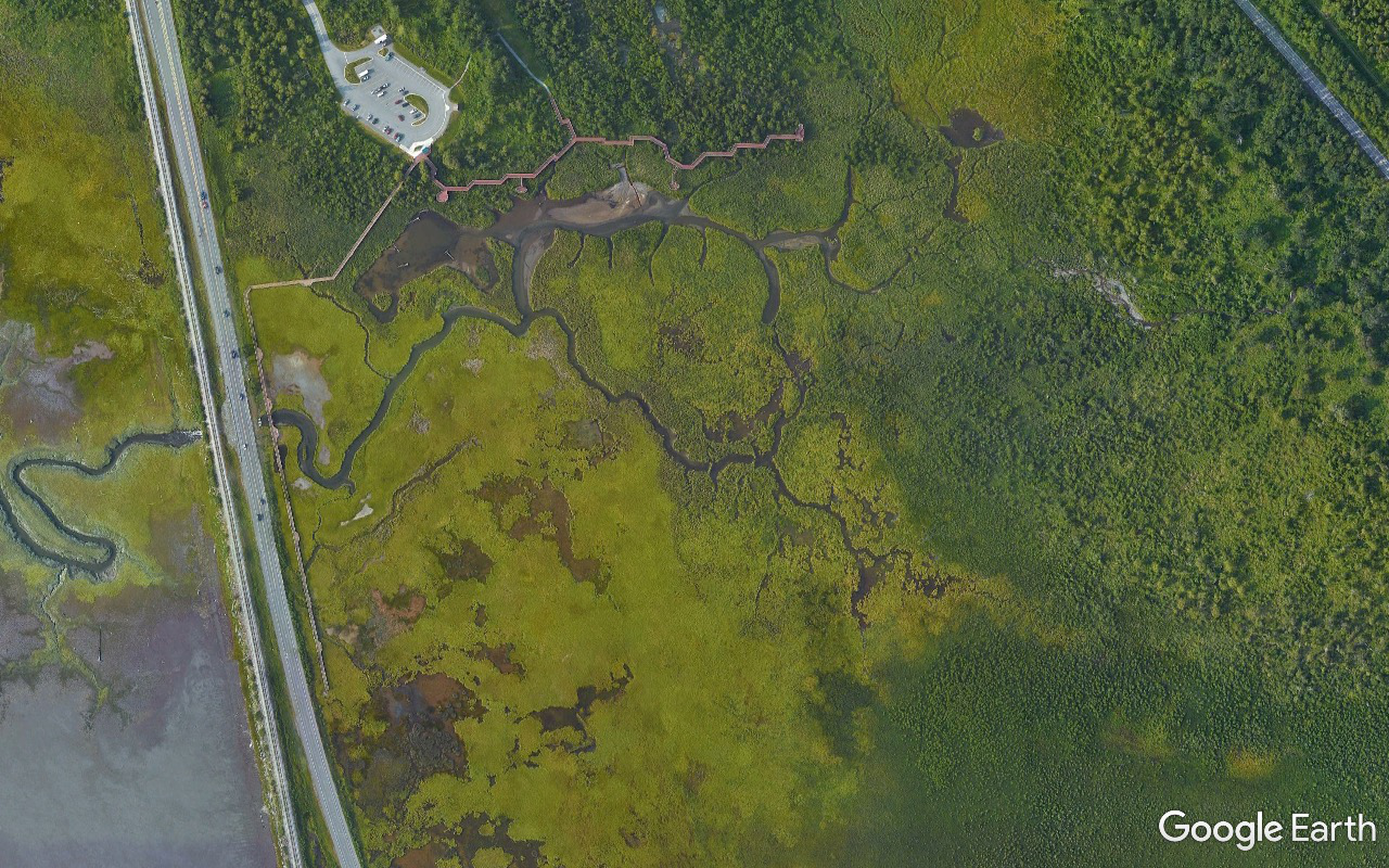
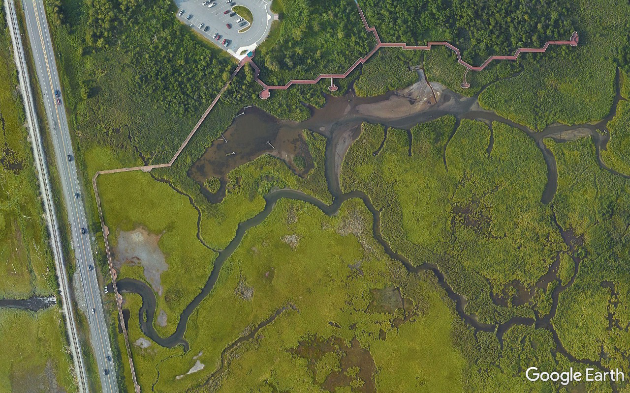
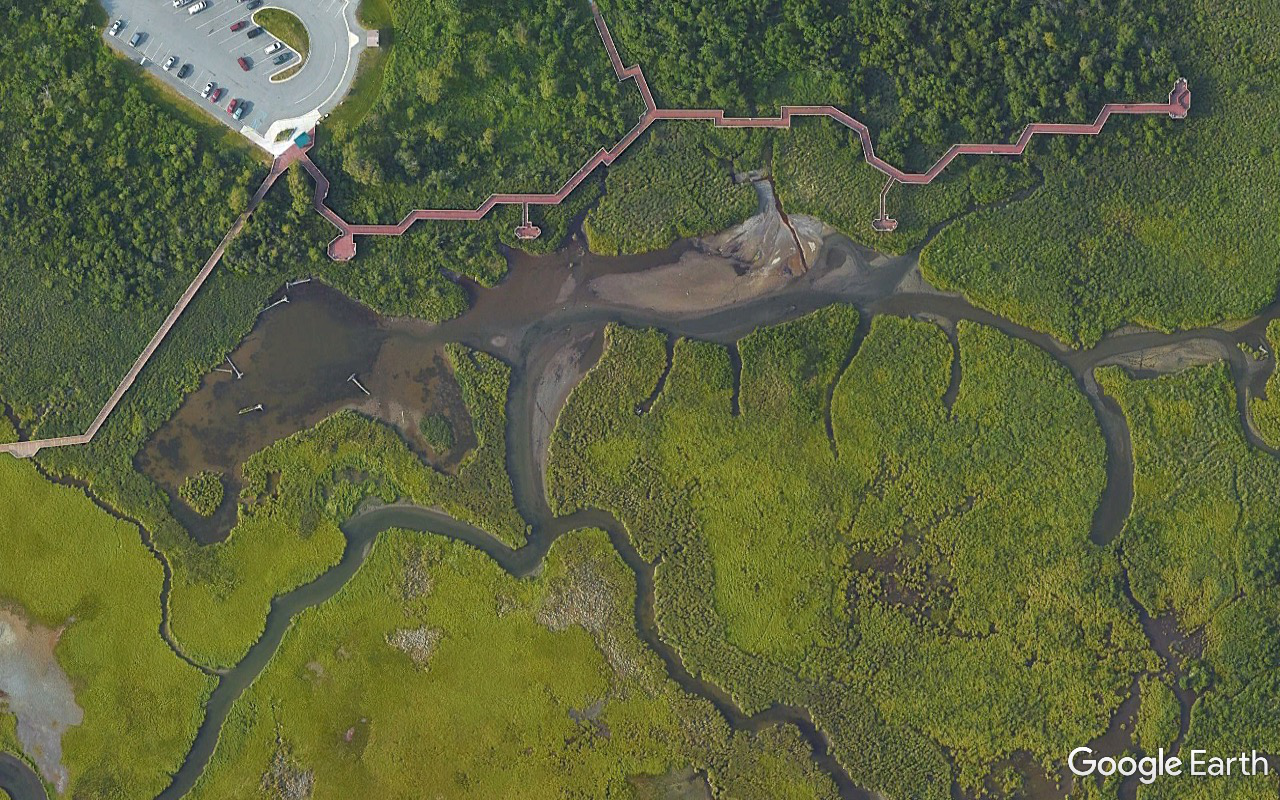
The Anchorage Coastal Wildlife Refuge extends along the shore down a wee bit of Cook Inlet from Point Woronzof and up a fair chunk of Turnagain Arm to Potter Creek (at the upstream end of Potter Marsh and just before the westernmost encroachment of the Chugaches on that shore).
Potter Marsh. Main entrance, parking, visitor facilities, boardwalks at the north end; a couple of pull-offs on the edge of the Seward Highway near the south end.
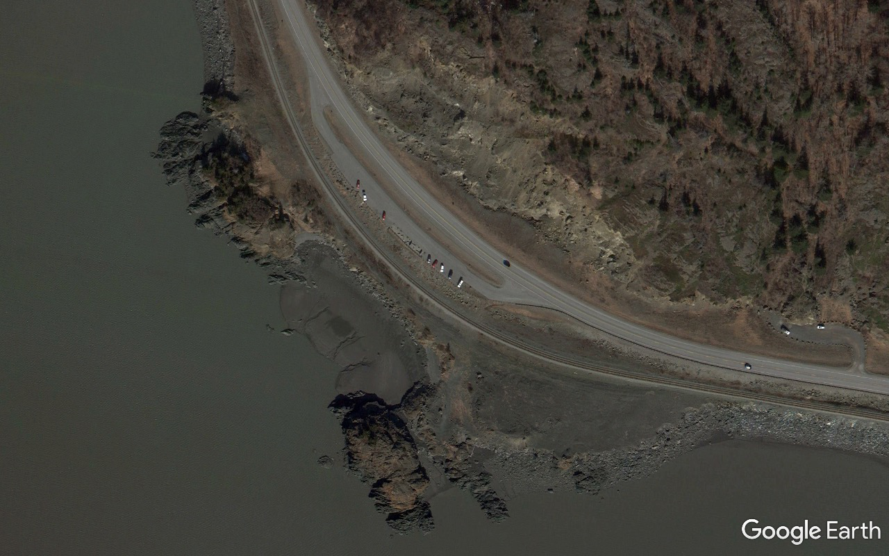
The two relevant Seward Highway scenic view accesses: downstream/WNW is Beluga Point; upstream ESE I'm calling the Rainbow Creek pull-off as it's officially unnamed.
The Raven needs to fly over only ten miles of terrain to get from one body of water to the other.
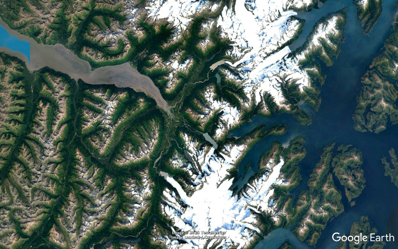
The Kenai Peninsula is the land area SSW of that land connection - defined by the Chugach Mountains watershed and reasonably well defined by the Portage Glacier Highway...
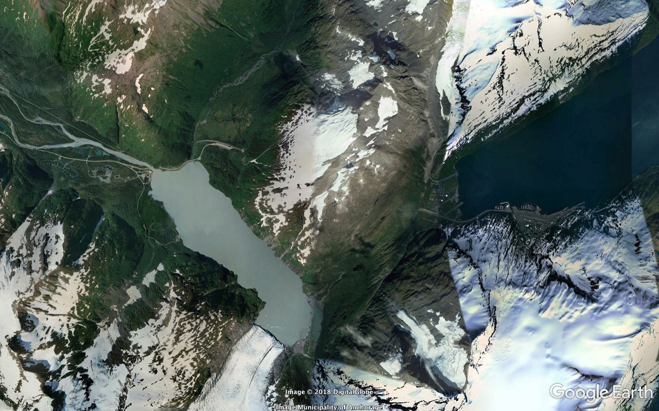
...'cept where it cheats and runs under (Robert L.) Maynard Mountain (3570 feet) courtesy of the two and a half mile long Anton Anderson Memorial (Whittier) Tunnel.
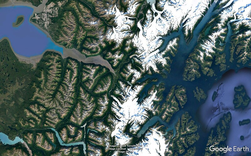
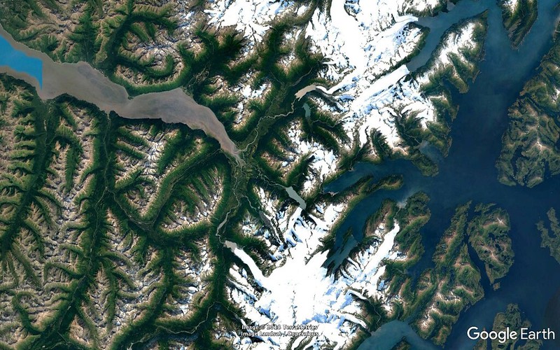
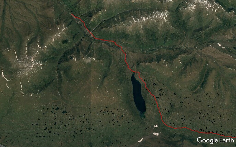
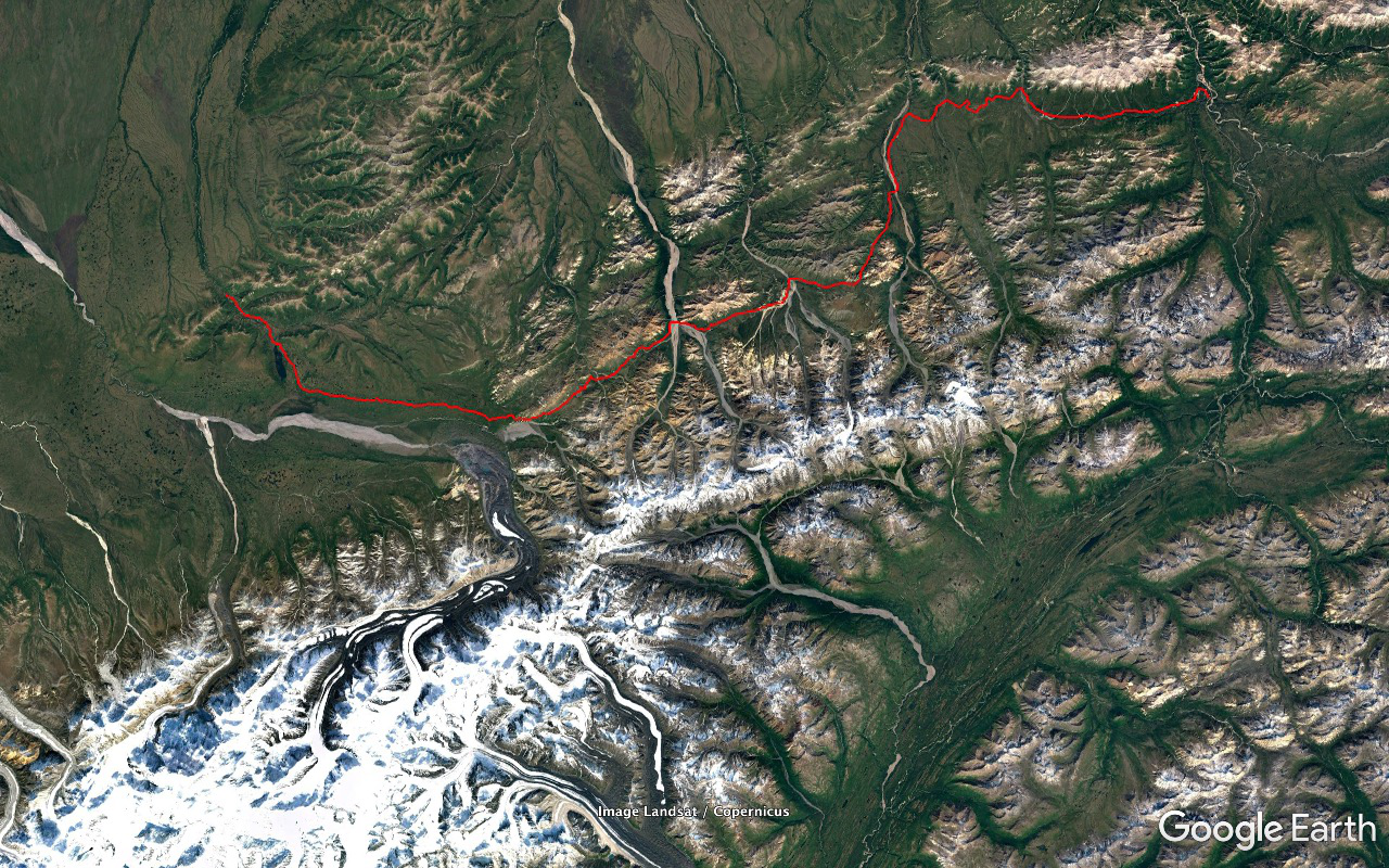
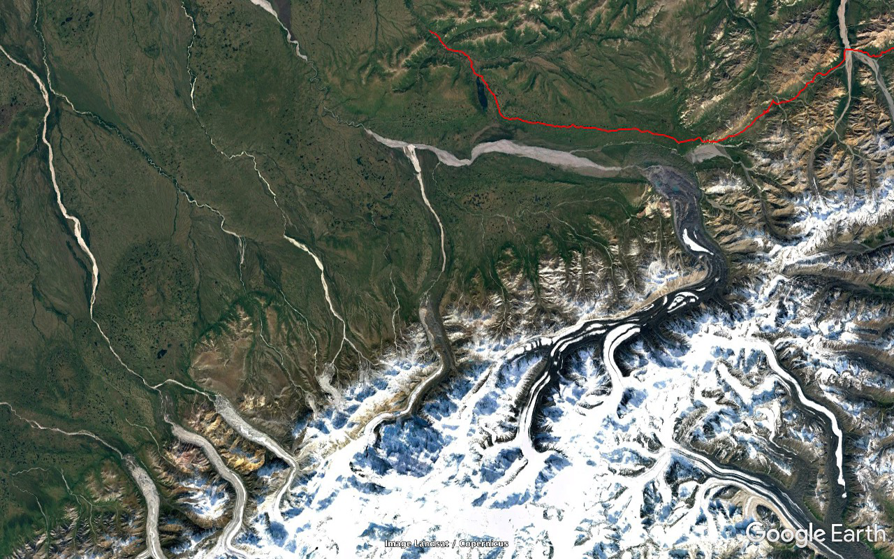
...traced in red from the point at which it turns away from the Turnagain Arm / crosses Ingram Creek / turns SW and runs through the Kenai Mountains mostly south 72.2 miles to its south end near the south end of city of Seward.
Traced in yellow is the 32.7 mile section of the Alaska Railroad from where it substantially parts company with the Seward Highway just upstream of the head of the Turnagain Arm to where it reconnects south of Upper Trail Lake at Moose Pass prior to continuing reasonably parallel to the Highway down to Seward. It's the more logical looking path but the Highway routes one with closer accesses to Sunrise and Hope, on the south shore of the Turnagain Arm, and Homer, way south down the Cook Inlet at the mouth of Kachemak Bay (off the SW corner of the frame.
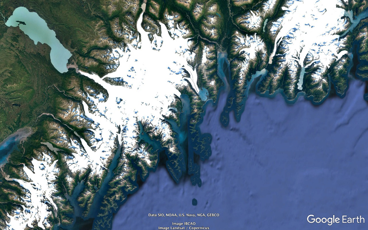
Seward is situated near the head of Resurrection Bay, the northernmost reaching fjord along that stretch of the coast of the Gulf of Alaska. Steam south down Resurrection Bay to the Chiswell Islands at the mouth of Aialik Bay, the next fjord to the southwest; enter Harris (the next) Bay, steam northwest into the Northwestern Lagoon (Fjord) to the Northwestern Glacier. It's named after the University and has nothing to do with the location or alignment of anything. You're now encroaching into Kenai Fjords National Park and its 700 square mile Harding Icefield expanse.
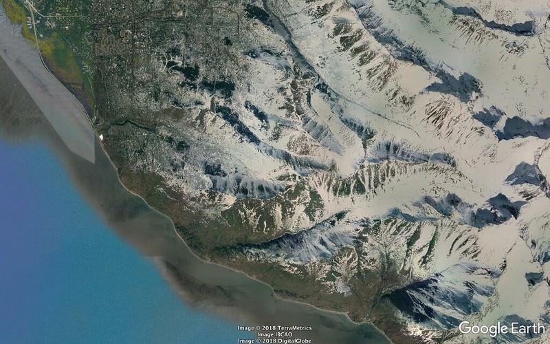
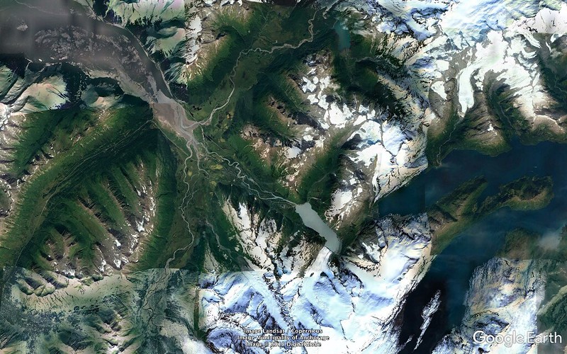
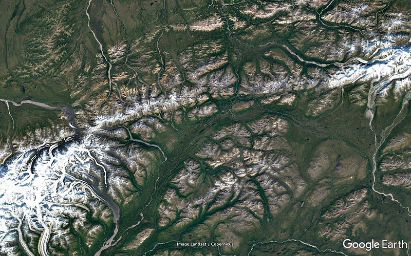
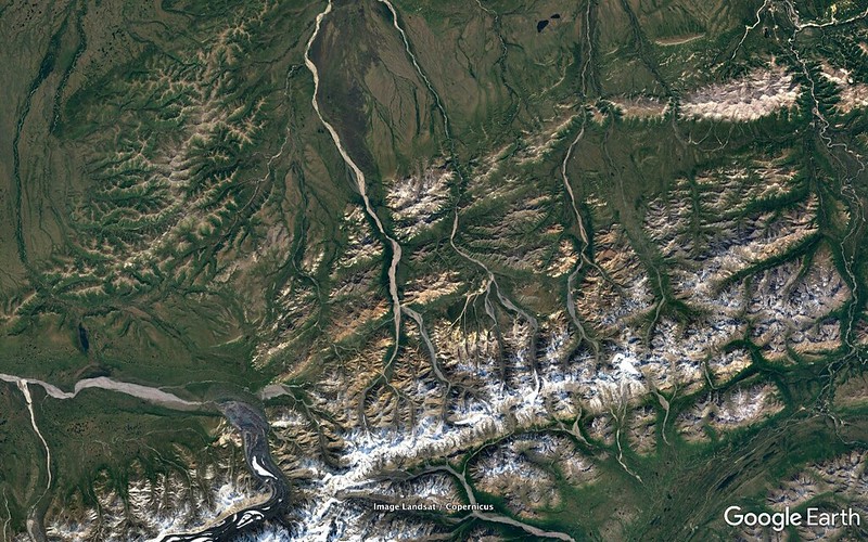
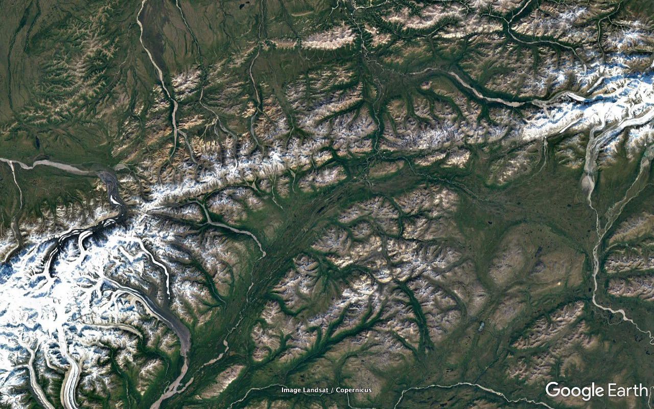
The really high stretch of the Alaska Range. Talkeetna is about 59 miles SSE of Denali at the convergence of the - west to east - Chulitna, Susitna, and Talkeetna Rivers en route from Anchorage to the Denali National Park entrance. Major access point for Denali climbing and flightseeing expeditions. Great viewing point for the mountain - weather permitting. Weather didn't come close to permitting either on the way up or the way back. The National Park access area is on the other side of the range.
Those are (William C.) Edes and Summit Lakes - NE and SW respectively - at Broad Pass. The elevation of the soggy ground between them is about 2340 feet. The water that oozes NE into Edes winds up in the Bering Sea by way of the Yukon. The water that oozes SW into Summit winds up in the Gulf of Alaska by way of the Susitna River and Cook Inlet. Seems like the divide should be the Alaska Range but the Nenana River cuts through it. Note the gap in the big picture shot two frames back.
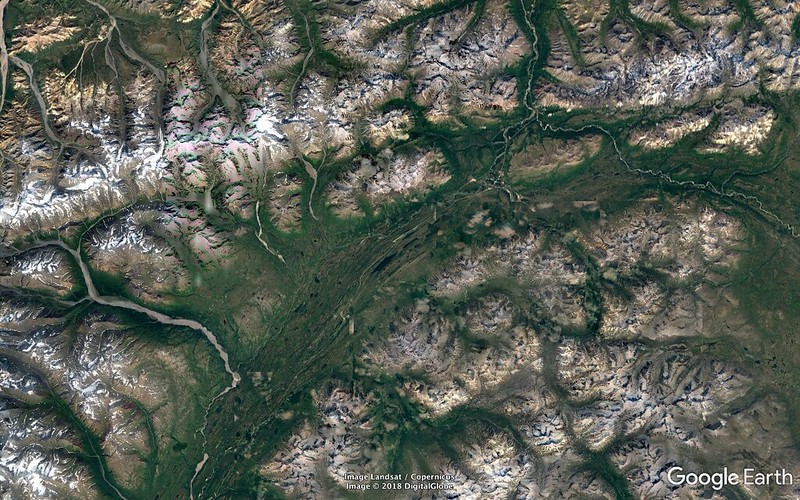
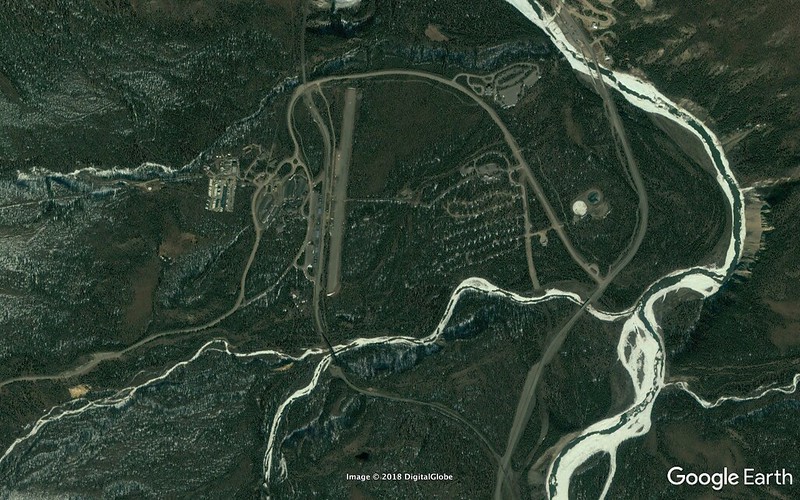
Denali National Park entrance / transportation hub on the Governor George Alexander Parks Highway 237 miles north of Anchorage and 120 miles south of Fairbanks. Some of the water flowing through the river at that point was contributed by Edes Lake - as per above.
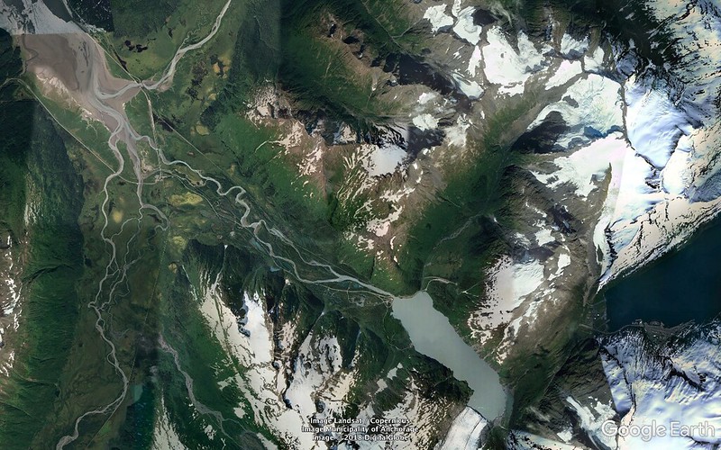
Same shot with the path of the Denali National Park Road drawn in. 92 miles from the Park entrance arrival point (two frames above) to its end at Kantishna. Since you're mostly traversing rugged terrain it's rare to find straight sections and thus it literally takes about three times the length of time to accurately trace it with a Google Earth path as it would to drive it.
Note the east/west aligned Healy Ridge range just north of the first fifteen driving miles of the road in - the only ones open to the public up to the Savage River crossing at 63°44'20.27" N 149°17'43.65" W, the road's northernmost point. Several stretches of the range's high edge run above six thousand feet.
About 90 permitted buses are allowed the rest of the way in on the Park Road for visitors to tour in and/or get shuttled in and out.
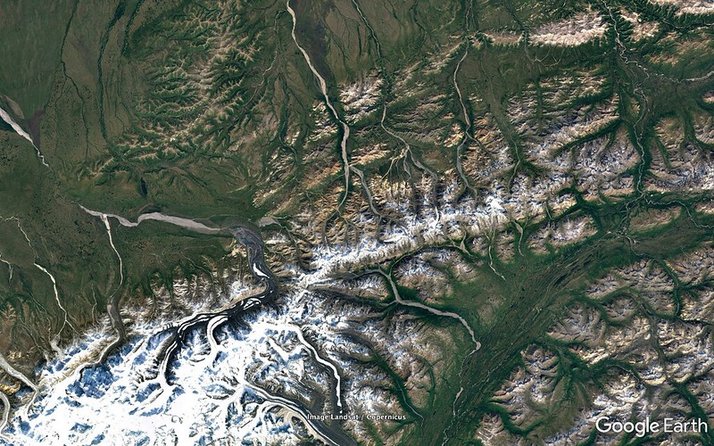
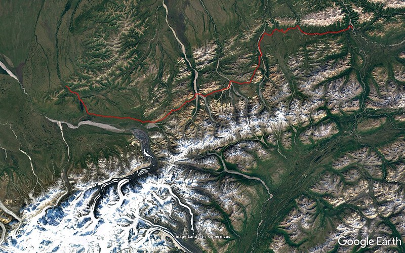
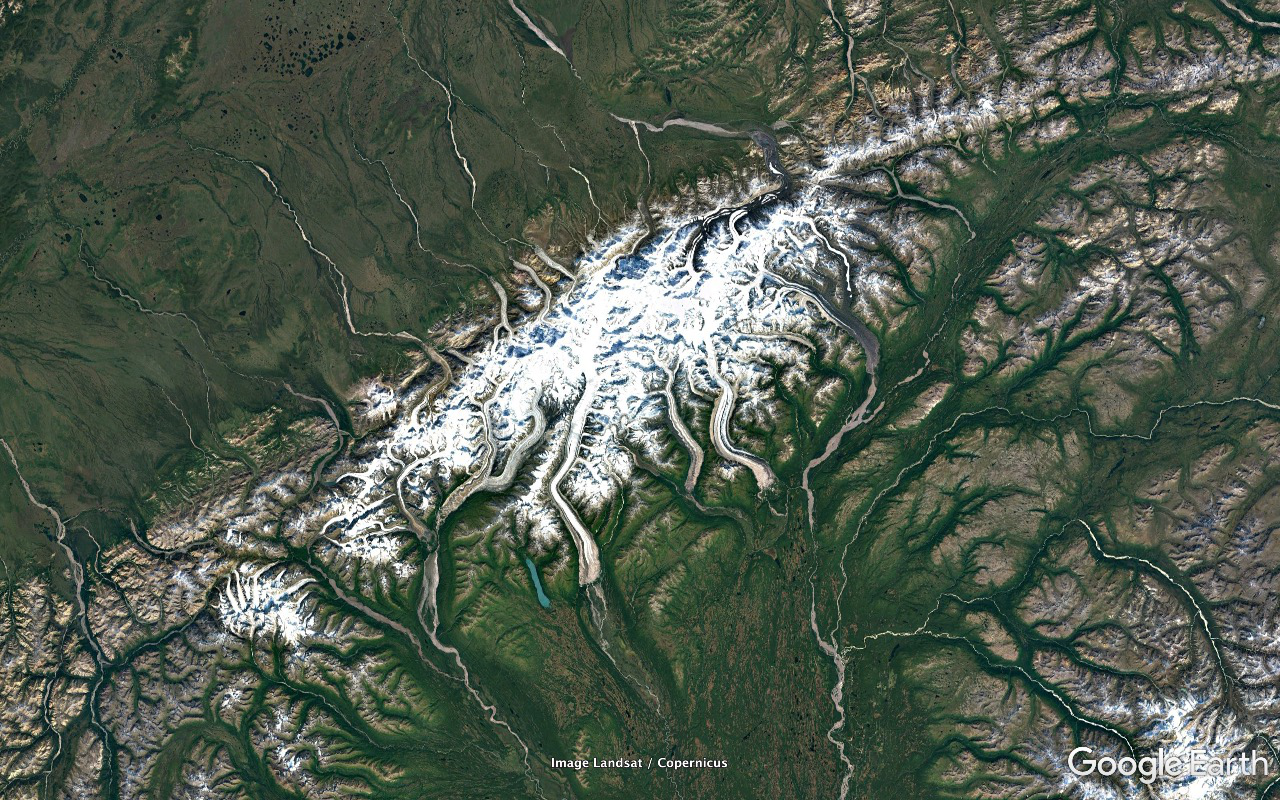
The really wide stretch of river pathway draining WNW in the left center of the frame is the (William) McKinley River which is what the (Robert) Muldrow Glacier becomes after leaving Denali's peak. The Muldrow Glacier used to extend way the hell out into the tundra and the carving effect it had on the landscape needs to be seen to be believed.
It's both fed at and drains from its north end and the drainage seriously meanders north the better part of 42 crow flight miles to feed into the McKinley River. Things eventually end up in the Yukon and Bearing Sea.
North Face Lodge, the Denali National Park inholding property at which our tour group stayed, is just a one and two thirds mile drive northish on the Park Road from Wonder Lake's north end and along its Lake Creek drainage. Immediately beyond the creek dumps into and the road crosses Moose Creek.
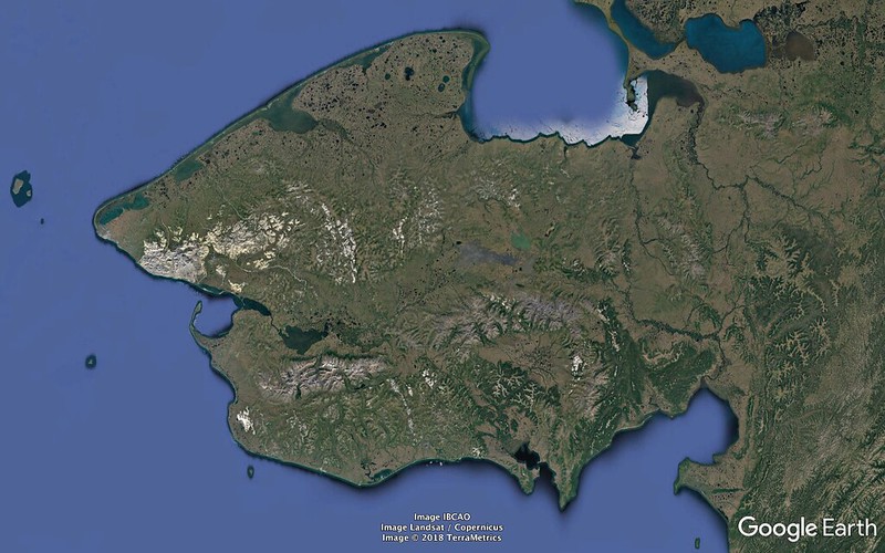
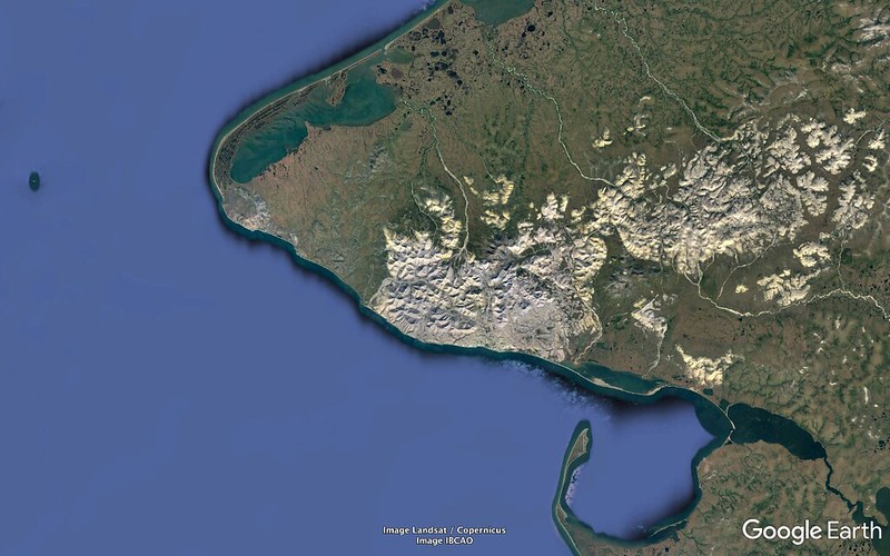
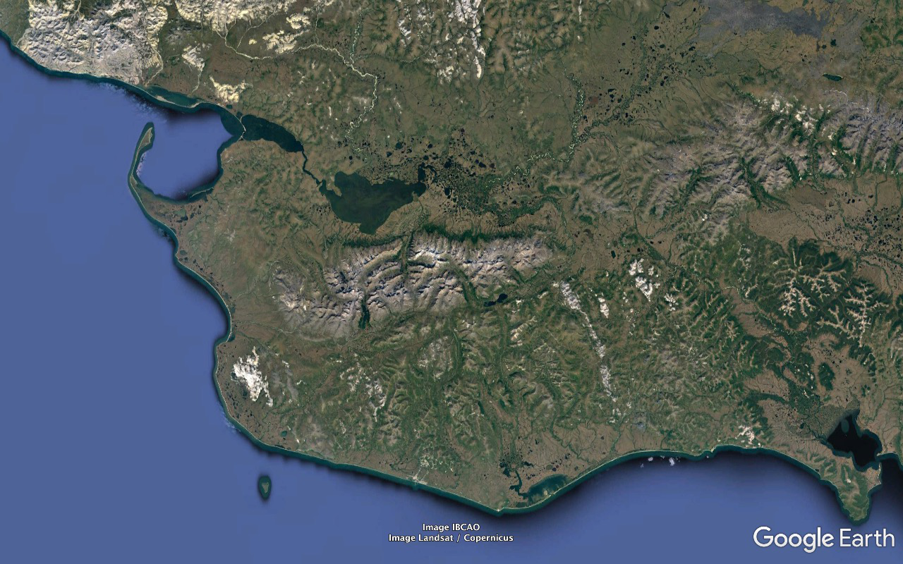
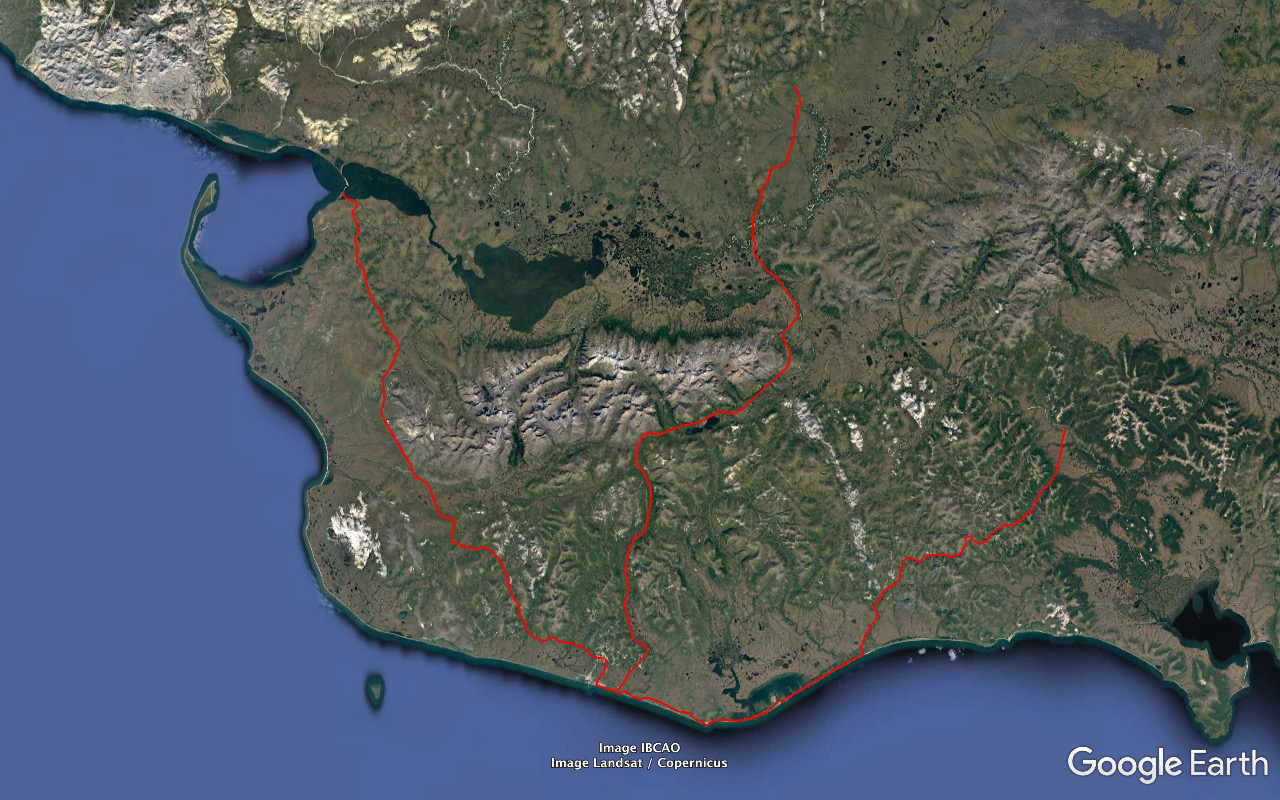
The Seward Peninsula.
Its top at Espenberg is sliced by the Arctic Circle.
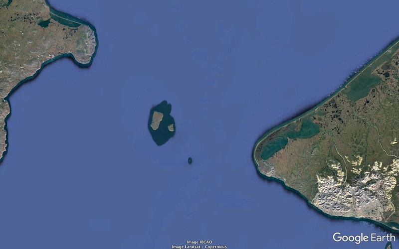
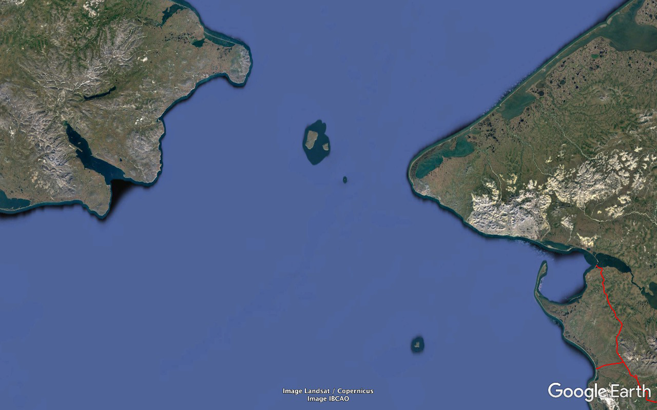
Big and Little Diomede Islands in the Strait split by Russia and the US and the International Date Line. If you fuck something up on Big just paddle - or if the weather's been favoring it for a while, walk across the ice - 2.4 miles over to Little and you've got nearly a full day for a do-over.
(Lieutenant James) King Island in the Bering Sea 62 miles SSE of the Diomedes.
Sledge Island two dozen miles west of Nome and half a dozen miles off the beach.
The Port Clarence bay to the ENE of King Island.
The Imuruk Basin draining into Port Clarence.
Mountain ranges:
- York - close to the Straight, north of Port Clarence and Teller
- Kigluaik - north of Nome, south of the Imuruk Basin
- (Otto von) Bendeleben - extending east and a bit north of the Kigluaiks and then starting to curve SE
- Darby - curving back south and SSW of the SSW of the Bendelebens to the coast of Norton Sound.
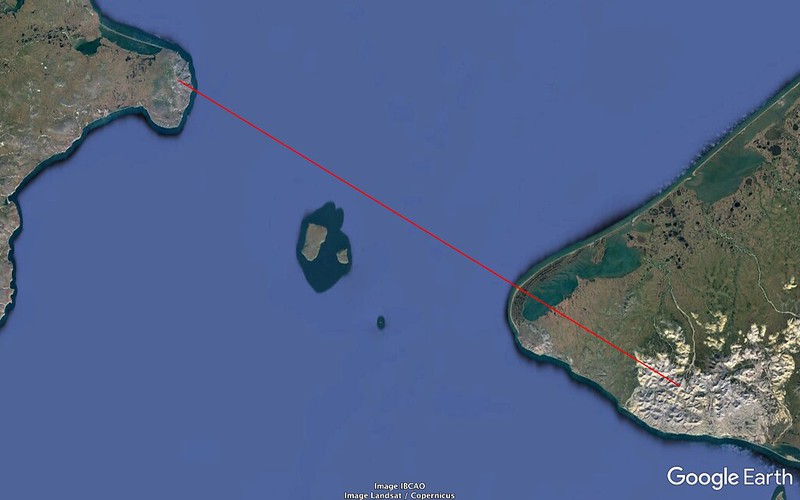
The Bering Strait.
About 51.2 miles of shallow water separating the continents.
The Diomede Islands plus Fairway Rock. The latter's 534 feet high and the Alcids appreciate it as a nesting site.
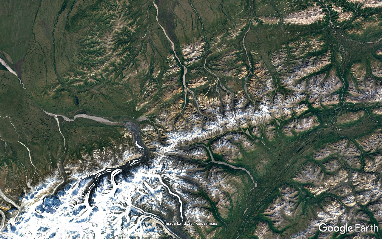
Zoomed in. There are high points of land not far in from the extremities on both sides. North America has a Google Earth high point of 2369 feet at 65°29'37.66" N 167°19'33.73" W in the York Mountains and Eurasia has a much less dramatic but slightly higher relevant max of 2388 feet at 66°05'41.89" N 169°43'00.28" W.
The straight line drawn between the two measures 79.73 miles. One standing at one would have no problem whatsoever seeing the other - along with everything in between and much more - at any time the sun and weather permitted.
These following four shots are centered and zoom in on the York Mountains high point. This range, I now realize, constitutes a pretty cool continental divide. Drainage to the SE goes to the Bering Sea / Pacific Ocean and to the NW the Chukchi Sea / Arctic Ocean.
The main Arctic Ocean bound river in this area of the range is the Mint. The main Pacific bound rivers are - west to east - the Kanauguk, King, and Rapid.
I can't find any reference to it anywhere and it doesn't appear to have a name. I kinda feel like I discovered it so... Mount Tad - until somebody with a better claim begs to differ anyway.
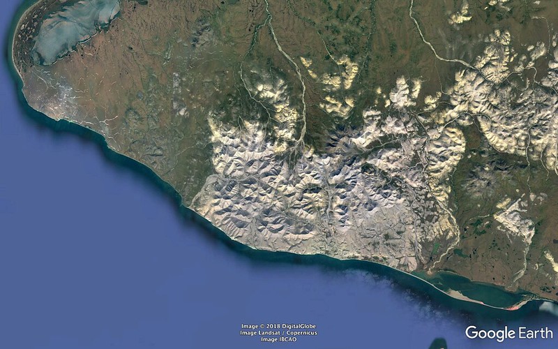
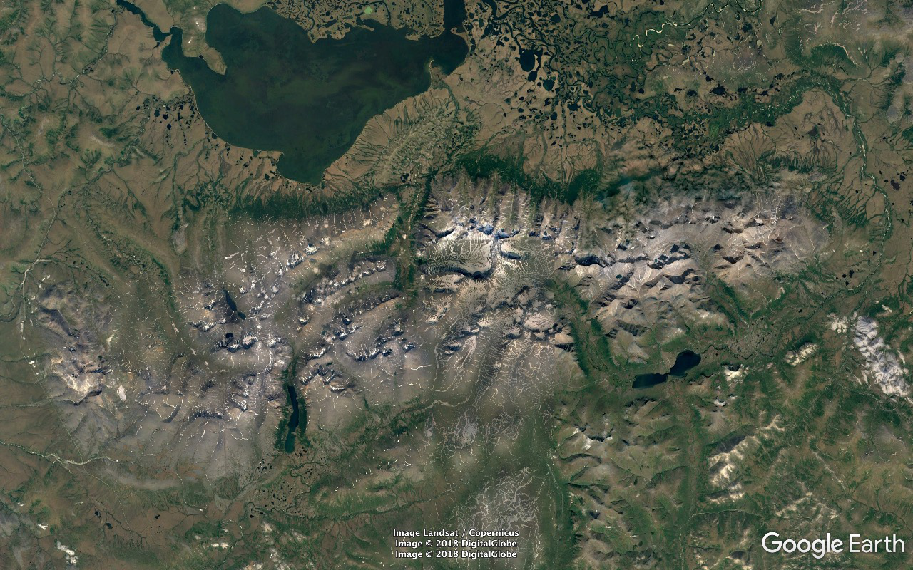
Southern Seward Peninsula.
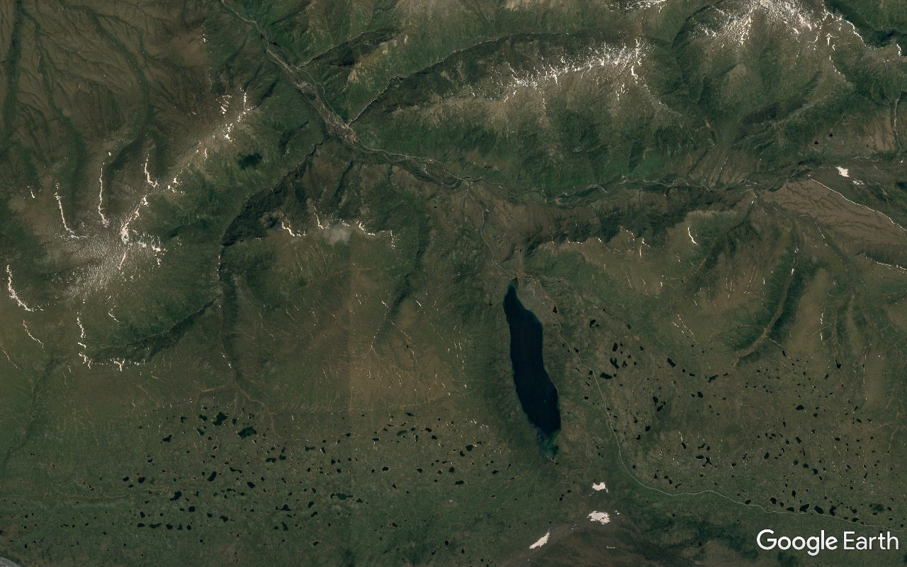
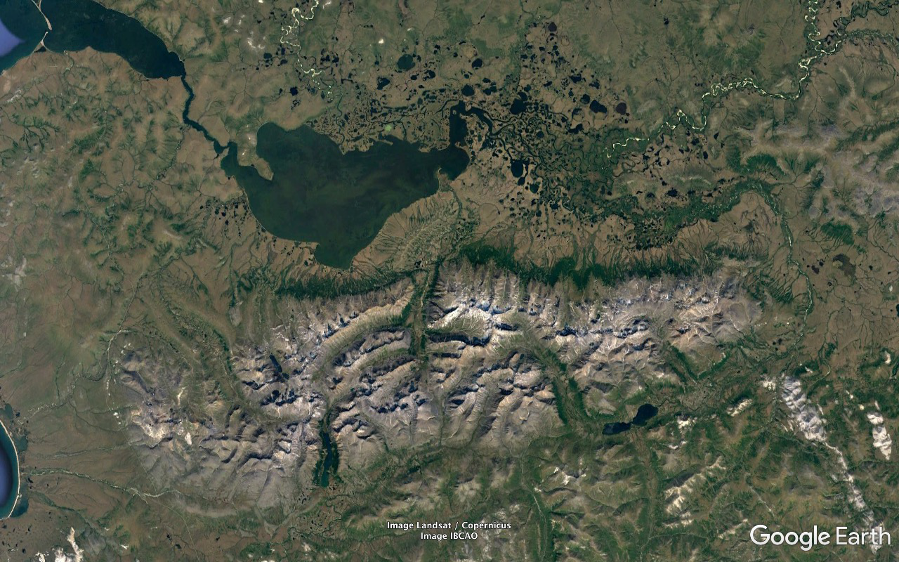
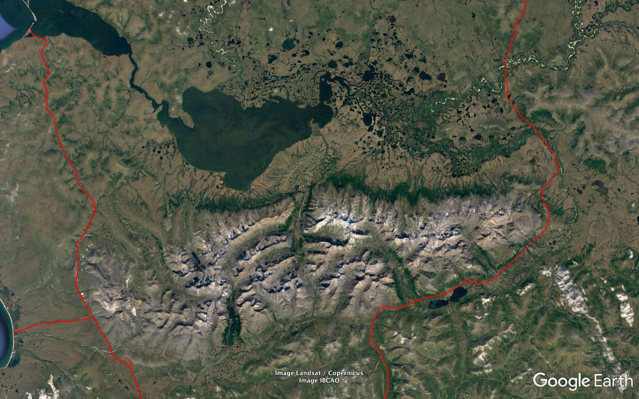
Kigluaik Mountains. Mount Osborn, 4714 feet, highest point on the peninsula, located where the mountains are whitest.
Bendeleben Mountains' high point is Bendeleben Mountain at 3730 feet and is considered by many to be more spectacular than Osborn due to its more isolated situation at the west end of its range.
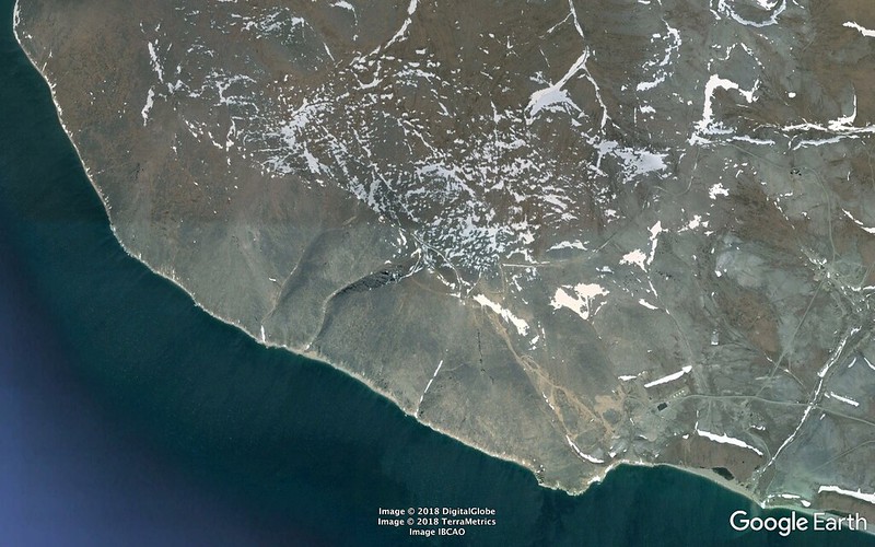
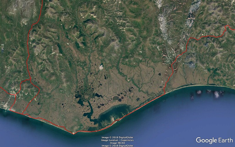
Nome on the SSW coast.
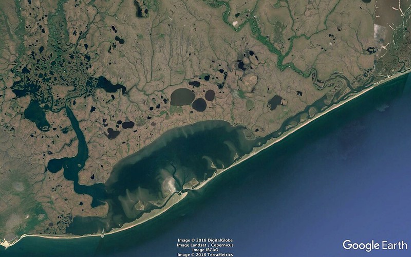
Safety Sound. Back east on the coast road and just around the bend. Lousy with really cool birds.
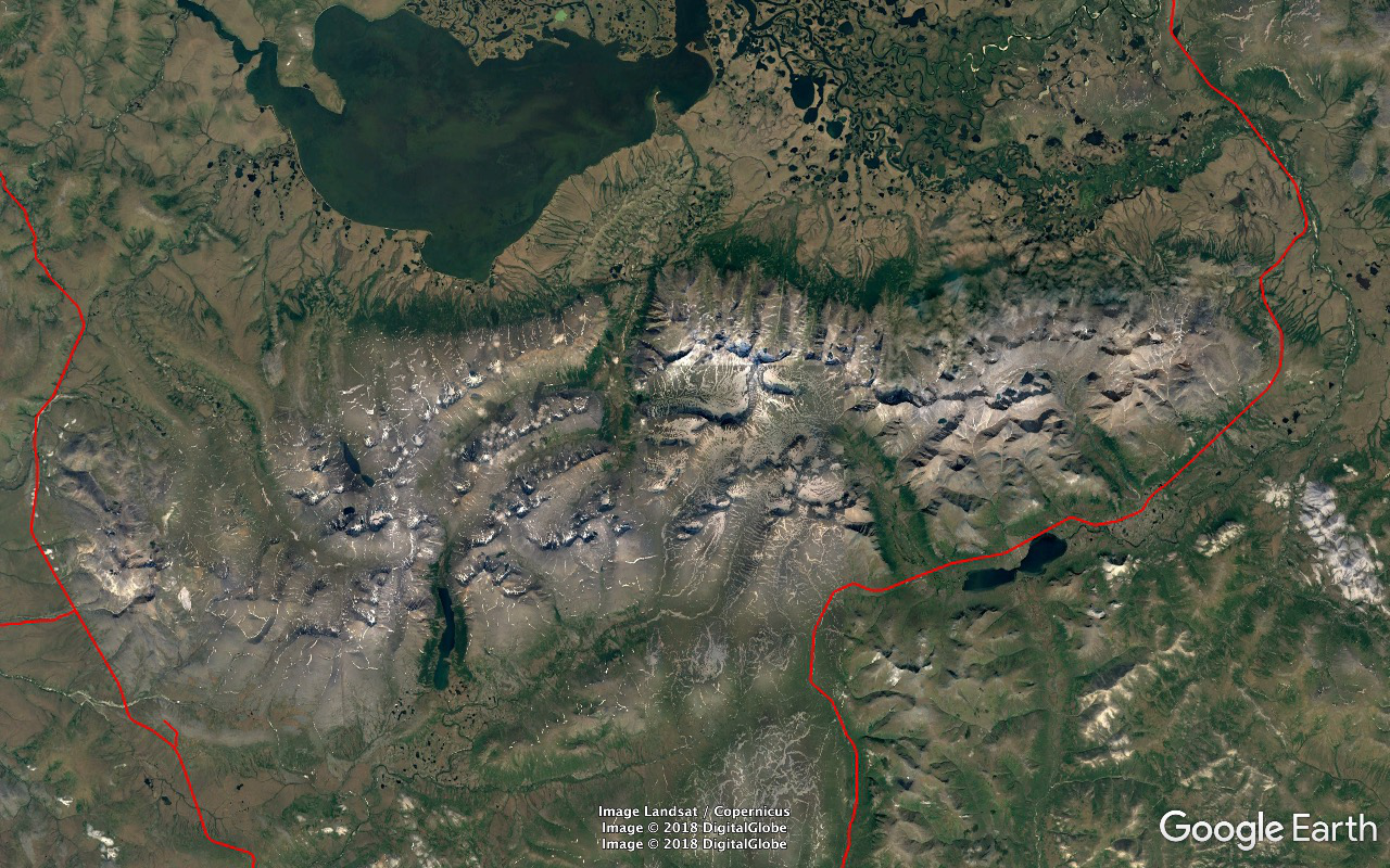
and again with the major roads plus a nice little shortcut just north of town, traced in. The only roads on the peninsula worth mentioning are these three radiating out of Nome. From east to west - Council, Kougarok, Teller. They're dirt/gravel but well maintained and you get a reasonably comfortable ride at reasonable speed just about all the time. If you go all the way up Kougarok and drive across the Kougarok River Bridge - which is as far as is possible in a road vehicle - you're 89.15 miles shy of the Arctic Circle at 66°33'47.00" North latitude.
The southwestern areas of the range drain into Norton Sound and the Bering Sea. Everything else - starting from around the Kougarok Road approach on around counterclockwise - makes it to the Bering Sea via Port Clarence.
Note the northernmost point - 64°53'38.37" N 165°12'54.20" W - on the Kougarok Road as it makes its turn to start paralleling the Kigluaik range to the ENE along its base. You can see it blown up better two frames down. That's on the Nugget Divide. 140 yards on and down a bit and you're crossing the bridge over Nugget Creek. That water's on its way to Port Clarence.
Back to just behind the aforementioned northernmost point the drainage is to Norton Sound via the Nome River back down the Kougarok Road just about all the way.
A hop, skip, and jump farther west and the drainage is to the mouth of Norton Sound via the Sinrock River.
Farther west and the Bering Sea proper via Wooley Lagoon.
And I'm gonna call 65°01'36.83" N 166°06'55.56" W - 0.85 miles to the NNE of the easternmost point of the Teller Road after it rounds the western end of the Kigluaik range - as the point on the divide between the Wooley Lagoon and Port Clarence drainages.
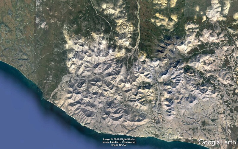
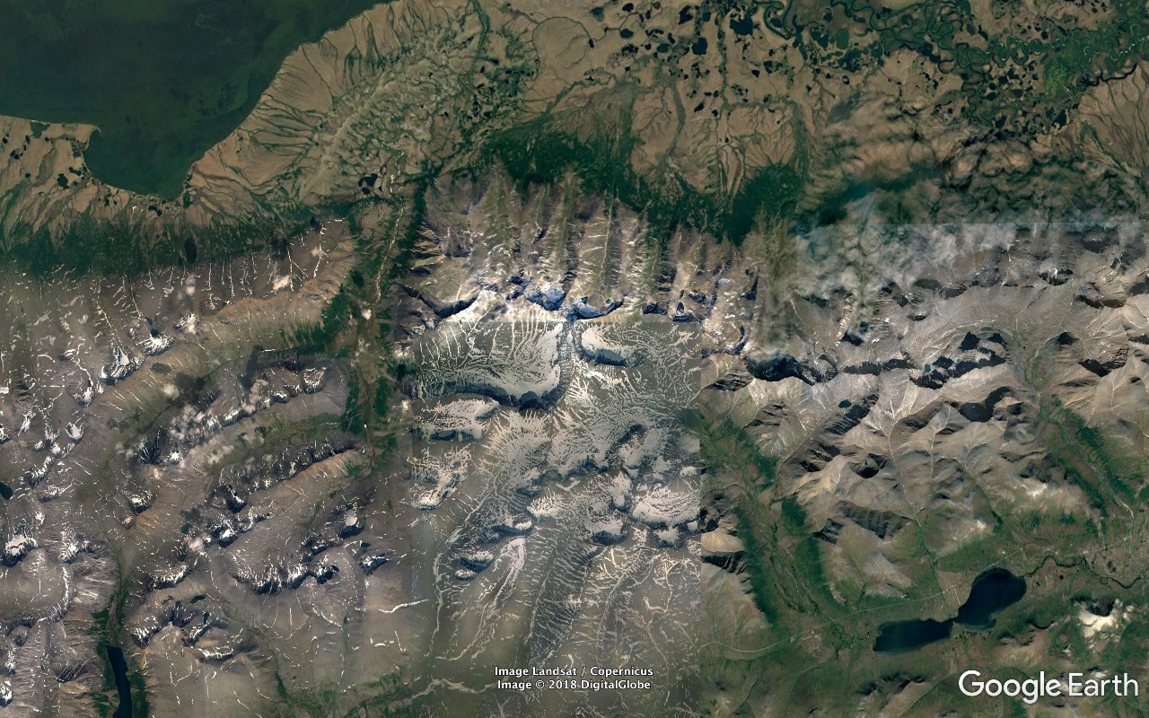
Dead centered on Mount Osborn. The Pilgrim/Kruzgamepa Hot Springs area is in the northeast corner of the frame near the southeast exposure of the green bulge associated with that bend of the Kruzgamepa River.
Salmon Lake is the body of water in the southwest corner of the frame - about four miles in length and nearly squeezed in half by some stream delta deposits - as best as I can figure. It's actually just a wide stretch in the river that originates at Mount Osborn and flows SSE out of the range, ENE towards that end of the range, north around the end, then mostly west along the north face to drain into the Imuruk Basin, Port Clarence, the Bering Sea.
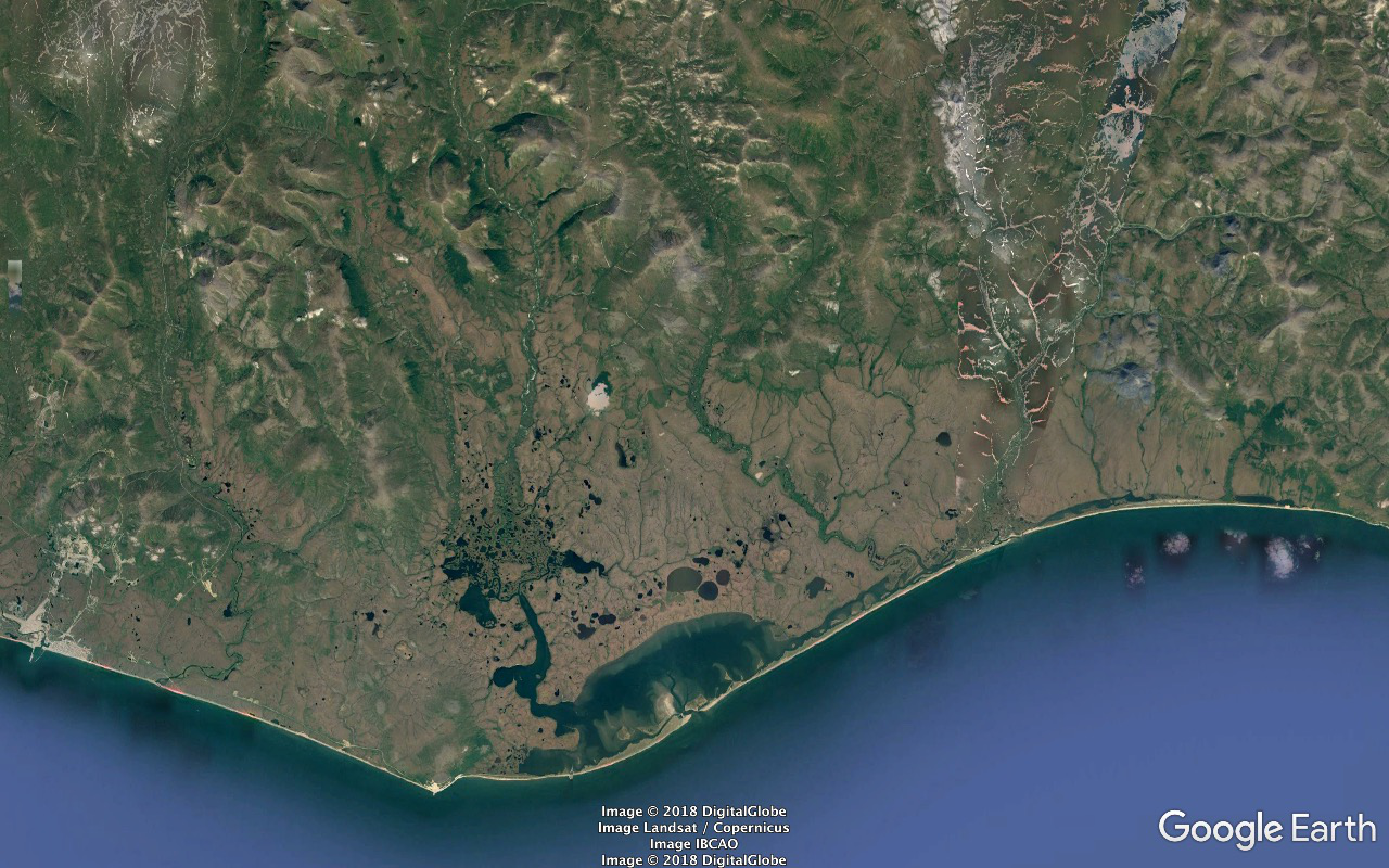
And some zoom-ins on the Norton Sound coast and Safety Sound / Alaska Maritime National Wildlife Refuge estuary areas...
Nome's at the west edge, Cape Nome is the southernmost extremity.
West to east the Eldorado, Bonanza, and Solomon Rivers are the biggies draining into the estuary area.
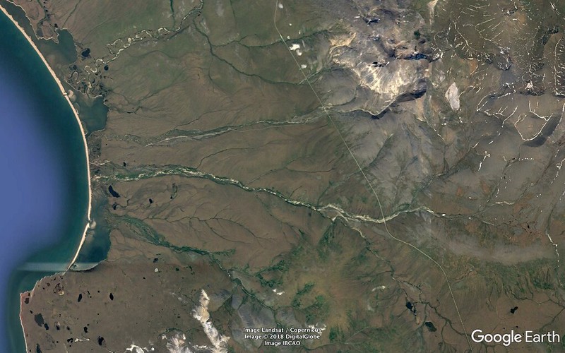
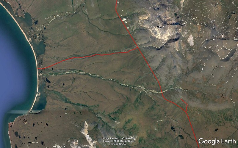
And some zoom-ins of the Wooley Lagoon area with a couple of spur roads of which we took advantage on the Teller Road excursion.
The main drainages feeding the estuary visible in these shots are - south to north - Fairview Creek and the Feather and Tisuk Rivers.
The spur road descending to the lagoon between the two rivers follows Crete Creek. Crete Creek Road, I find now after having identified the creek.
88 - 64°50'59.27" N 166°11'42.77" W - 0015.39 miles http://c1.staticflickr.com/1/847/29279934968_95061fe514_o.png
89 http://c1.staticflickr.com/1/916/28281648237_22d81dc133_o.png
---
Amended:
2018/07/01 04:10:00 UTC
2018/07/01 13:45:00 UTC
2018/07/01 17:20:00 UTC
2018/07/02 13:40:00 UTC
2018/07/04 14:40:00 UTC
2018/07/04 22:15:00 UTC
2018/07/05 01:45:00 UTC
2018/07/05 12:50:00 UTC
2018/07/06 04:30:00 UTC
2018/07/07 14:25:00 UTC
2018/07/08 01:45:00 UTC
2018/07/08 17:30:00 UTC
2018/07/12 22:55:00 UTC
2018/07/13 14:45:00 UTC
2018/07/14 23:40:00 UTC
2018/07/15 07:05:00 UTC
2018/07/15 15:15:00 UTC
2018/07/17 19:45:00 UTC
2018/07/21 22:40:00 UTC
2018/07/22 16:40:10 UTC
2018/07/29 18:00:00 UTC
2018/08/10 19:05:00 UTC
Edited/Corrected:
2018/07/08 18:15:00 UTC
2018/07/13 18:45:00 UTC
2018/07/25 02:15:00 UTC
2018/07/26 14:55:00 UTC
That miserable arrival in Anchorage was the only point at which darkness was experienced in the duration of the excursions within Alaska. Reasons:
- approaching:
-- the summer solstice four days ago
-- the Arctic Circle / Land of the Midnight Sun
- Alaska Time Zone is pretty much a total joke
The territory of the state of Alaska spans almost as much longitude as the contiguous United States (57.5° vs. 57.6°) so the use of two time zones will inevitably lead to some distortions. Alaska would "naturally" fall into four time zones, but political and logistical considerations have led to the use of two, leading to the distortions mentioned above.
The other zone is Hawaii-Aleutian and applies to the Aleutians beyond 169°30' West longitude. This time of year if you make the short hop from Umnak to Chuginadak Island you gain two hours since Alaska does Daylight Saving Time and Hawaii doesn't.
If you go by the concept of noon as the sun being at its high point Juneau's in pretty good shape - being just under 21 miles east of 135 degrees West longitude, nine Standard Time hours behind the Royal Observatory at Greenwich. And damn near everybody else in Alaska is substantially to majorly screwed.
The next fifteen degree / hour increment line - 150 - cuts through both of the Ted Stevens Anchorage International Airport runways. So when the clock says midnight ADT the sun says 22:00 (23:00 if doing AST).
Our next and westernmost (and northernmost) base of operations was Nome - another fifteen (and just shy of another half) degrees out. So add another hour to the offset. Actual midnight is Three AM hotel clock time. And we're just about 143 miles south of the Arctic Circle so when the clock's showing midnight the sun looks a lot like mid afternoon.
A little longitude exercise I did to put things in more temperate zone perspective...
61°10'38.96" N 149°56'30.90" W - Lakefront Hotel, Anchorage
64°29'46.92" N 165°23'51.69" W - Aurora Inn, Nome
15°27'20.79" - longitude difference
Set the White House as your eastern anchor point and go west that increase. You're halfway between Saint Louis and Kansas City - about half a mile west of Tadpole Island on the Missouri River.
The 1964 Alaskan earthquake, also known as the Great Alaskan earthquake and Good Friday earthquake, occurred at 5:36 PM AST on Good Friday, March 27. Across south-central Alaska, ground fissures, collapsing structures, and tsunamis resulting from the earthquake caused about 139 deaths.
Lasting four minutes and thirty-eight seconds, the magnitude 9.2 megathrust earthquake was the most powerful earthquake recorded in North American history, and the second most powerful earthquake recorded in world history. 600 miles of fault ruptured at once, and moved up to 60 feet (about 500 years of stress buildup). Soil liquefaction, fissures, landslides, and other ground failures caused major structural damage in several communities and much damage to property. Anchorage sustained great destruction or damage to many inadequately earthquake-engineered houses, buildings, and infrastructure (paved streets, sidewalks, water and sewer mains, electrical systems, and other man-made equipment), particularly in the several landslide zones along Knik Arm. Two hundred miles southwest, some areas near Kodiak were permanently raised by 30 feet. Southeast of Anchorage, areas around the head of Turnagain Arm near Girdwood and Portage dropped as much as 8 feet, requiring reconstruction and fill to raise the Seward Highway above the new high tide mark.
I was still shy of eleven at the time and remember the reporting. Plenty of dramatic evidence of what happened still around that neck of the continent.
Next day we blow the Puffin Inn and go 0.2 miles to the SSW to the Lakefront to link with the tour package.
Lunch on the deck out back on the Lake Spenard / Hood Canal / Lake Hood float plane hive. The birds like it too and I've got an excuse to set the scope up for the first time. My first ever Barrow's Goldeneyes, a pair, and the scope will, and did, function as a homing beacon for other arriving group members. We pick up Terry from the Seattle area pretty quick. Also score Red-Necked Grebe, Greater Scaup, Widgeon, Tree Swallow, an Eagle. (Eagle means Bald unless specified otherwise).
Weather's pretty nice - comfortable temperatures and lotsa blue.
Chugach Mountains behind us, Alaska Range in front.
Group assembles for dinner at the Lakefront. Tomorrow - Nome and the Seward Peninsula.
I'm travelling with:
- carry-on:
-- clothing worn including boots, leather jacket, cap
-- Canon 10x42s harnessed on
-- soft North Face backpack:
--- Swarovski:
---- ATX scope - protected in SOC case and stuffsack
---- DH101 tripod head
--- Leitz 7x42s (spare/loaner glasses)
--- Garmin GPS receiver
--- meds
--- Walkstool
-- soft laptop carry case
--- MacBook Pro
--- iPad (bird field guide)
--- gadgets chargers, cords, adapters, batteries
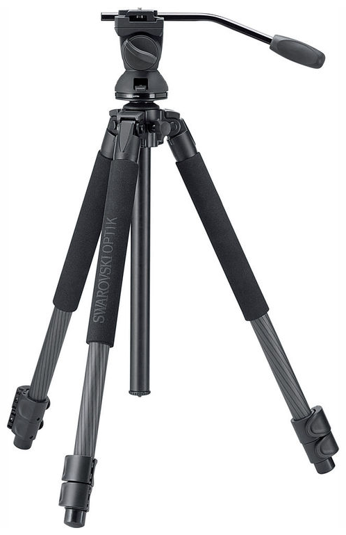
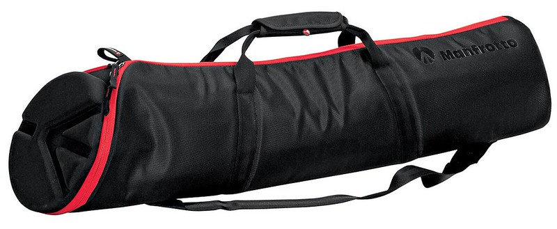
- checked - Manfrotto 100 centimeter Padded Tripod Bag:
-- 1:
--- Swarovski CT101 Carbon Tripod and PTH Head assembly
--- trip clothing and equipment
-- 2:
--- Swarovski CT101 Carbon Tripod
--- trip clothing and equipment
The arrangement was such that the most expensive and mission critical stuff would be with me and under my control at all times (in theory) and if the checked stuff were misrouted, lost, stolen, run over by a forklift I'd still be able to get back in business with stuff available in Anchorage.
...were strategically packed to their hilts. Clothing and other soft stuff was arranged to protect the tripods to the max extent possible and there were precious few cubic inches left to be exploited anywhere. In order to zip the bags closed I needed to use nylon webbing straps to cinch and compress the contents working from aft/narrow to fore/fat ends and following incrementally with the zipper. Getting them ready to fly required a lot of effort and would eat up something in the ballpark of half an hour. Needed to do that prior to:
- BWI-SEA-ANC - 2018/05/30-31
- ANC-OME - 2018/06/02
- OME-ANC - 2018/06/06
- Denali-Anchorage (Alaska Railroad) - 2018/06/11
- ANC-SEA - 2018/06/18
- SEA-MKE-BWI - 2018/06/19
Should've been able to skip that last one but for my peace of mind I needed to inventory and reorganize when less pressed for time.
And Alaska required some cold protection layers that shouldn't be needed for less extraordinary trips and I identified some just-in-case items that should've been left home so things should be significantly less demanding on any future excursions.
A big problem with having things neatly, anally organized and stowed in packs, cases, bags with lotsa compartments and subcompartments is that when field reality rears its ugly head and necessitates rearrangement it becomes ultra easy to lose items just this side of irretrievably. And throw jet lag, sleep deprivation, exhaustion, stress into the equation...
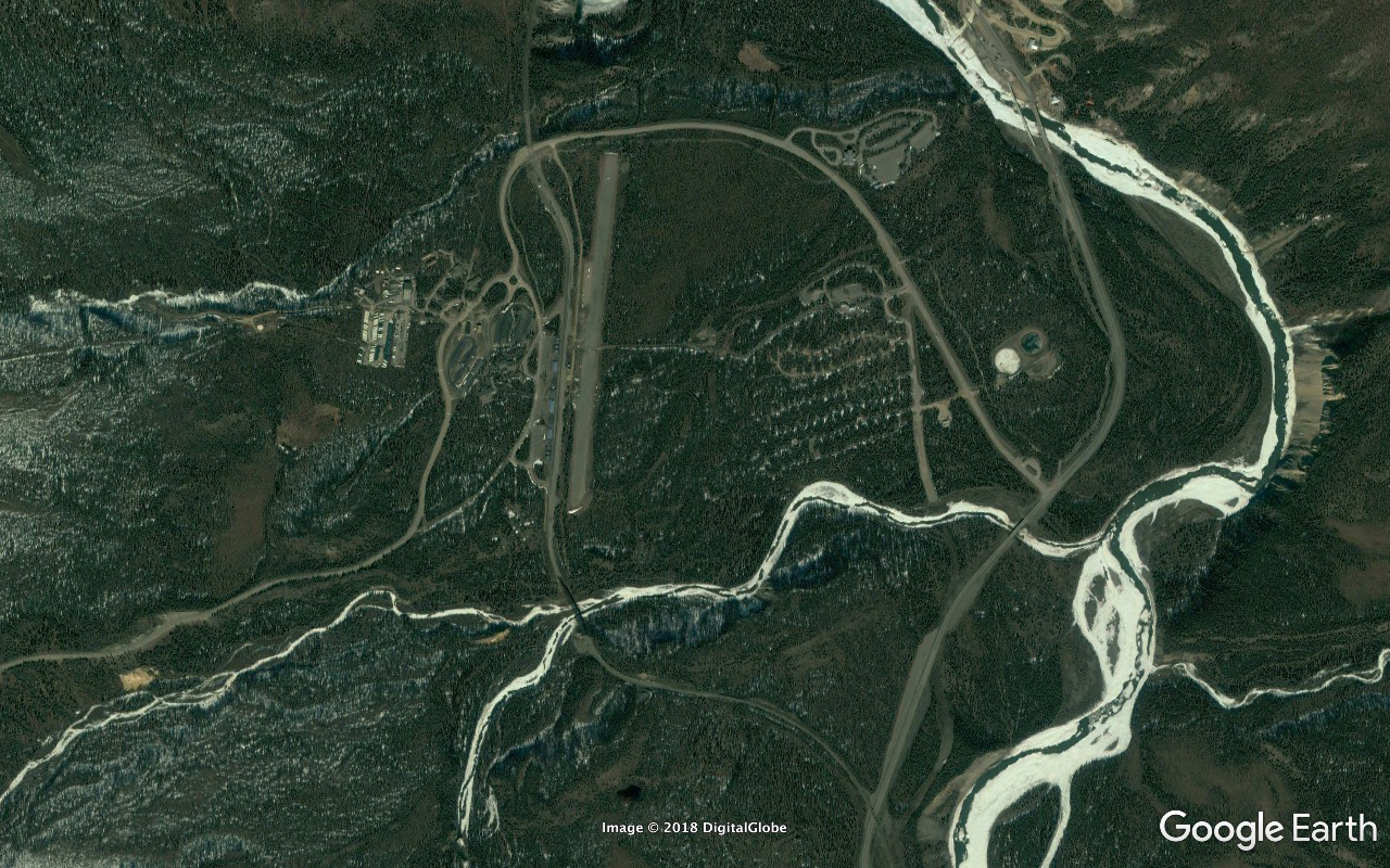
2018/06/02 we load onto Alaska Air 151 for the 10:06, 539 mile, hour and a half hop to Nome. I'm in 24F on the window, the weather's great, and as we taxi west for Runway 32 the port side of the plane has the sun. And as we approach the turn point I'm looking almost straight down the runway at the highest peak on the continent - Denali, 29028 feet, 135.4 miles to the NNW, gleaming white, looking like you could reach out and touch it.
Seeing that mountain had been a major item on my Alaska to-do list. I read that seventy percent of tourists similarly inclined strike out and I was majorly pissed that the 2018/05/30 Southwest fiasco had cost me one of my major opportunities right off the bat. And I hadn't the slightest freaking clue that the mountain could be visible from the surface in Anchorage - let alone having a view that spectacular.
Also got Foraker and Hunter, 17400 and 14573 feet respectively, thrown into the deal.
24E was a young ecotour guide who'd grown up in the Prince William Sound area (Cordova maybe) and he was a fucking encyclopedia on all of the million questions I had on the flight. (Wouldn't have known what those other two peaks were otherwise.)
Got to see Denali almost forever but eventually started worrying about doing serious damage to my neck and (un)turned my attentions to all the unpopulated Kuskokwim/Yukon watershed tundra expanse below.
And not long before we're over Norton Sound and checking out the south coast of the Seward Peninsula.
This is the segment of the trip to which I'm most looking forward, the weather's great, everything's lining up, I start feeling excited, then think of Quinn. (Nice try.)
We go wide and land back to the east. Blazing sun, dry, cool, strong steady wind. The passengers mass to recover checked luggage. Everyone and his dog is harnessed with glass - mostly Swarovski it appears. At major airports I'll be the only one out of untold thousands.
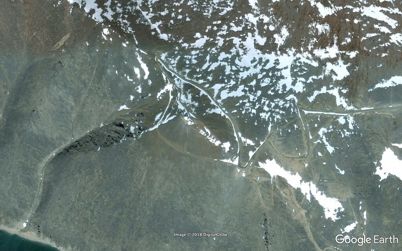
A sixteen year old Indian kid - returning home from hockey camp in Anchorage - asks me about our mission and plugs Pilgrim (Kruzgamepa) Hot Springs. I've checked it out in doing research for the trip, know where it is and a bit about it, but ask why. He talks about how beautiful it is. But I know it won't be an option what with the group situation.
Our two guides - Greg Smith and Xavier Muñoz, lead and sidekick respectively, head out to retrieve the rental van and SUV. I hear a familiar croak and turn to get my first Seward Peninsula bird - a Raven on a nearby utility pole.
Get shuttled a Raven flight mile and a half back down the coast to our Aurora Inn lodgings where we're to be allotted a half hour of settling in time before heading out on our tour's first outing. Guess whose room isn't yet ready.
I desperately need to reconfigure from plane travel to field trip mode and that's gonna be a fairly major operation. And all I can do with my precious minutes is continue to sit on my ass in the lobby. Half of my prep time goes down the toilet. "Sorry, still not ready."
My brain kicks in and I haul my gear to the room anyway. Indian staffer is doing the other bed and I ask if it would be OK if I prepped in the completed/far half of the room while he finishes up. Sure, no problem.
So I tear apart bags, assemble tripods, sort out field gear while multitasking with a pleasant conversation with the staffer. Greg sticks his head in, asks if I can complete assembly in the van. "NO." (way in hell.) "But I'll have stuff ready to load inside of the next two minutes."
Goddammit. Everybody else gets a half hour to settle in and prep. Through no fault of my own I get zero minutes to settle in and am working my ass off to prep optical equipment which is gonna benefit the entire group. I'm NOT gonna be rushed into heading out half cocked with armfuls of partially assembled gear wondering what I've forgotten or dropped.
And I end up properly prepped and loaded before Greg's ready to roll.
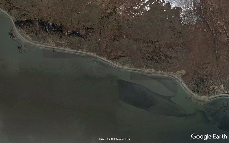
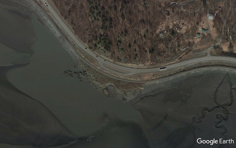
I'd probably rate our first second-half-of-the-day outing east on Council Road along Norton Sound as my personal trip high point. I've just arrived on another planet, weather's outstanding, with the sun medium high in the south the lighting's perfection for everything at which we're looking on the estuary side of the road, damn near all the birds are either new or new with their breeding plumage.
I got a Red-Throated Loon very close in just out of town. None of us wanted to leave it and move on but it was only the first of zillions. Snow Goose, Brant, Tundra Swan, Gadwall, Widgeon, Shoveler, Pintail, Green-Winged Teal, Greater Scaup, Common Eider, Red-Breasted Merganser, Red-Necked Grebe, Sandhill Crane, Semipalmated and Western Sandpipers, Red-Necked Phalarope, Long-Tailed Jaeger, Arctic Tern, Lapland Longspur. A nest of Ravens in the arm structure of and abandoned crane with huge begging kids not far from fledging.
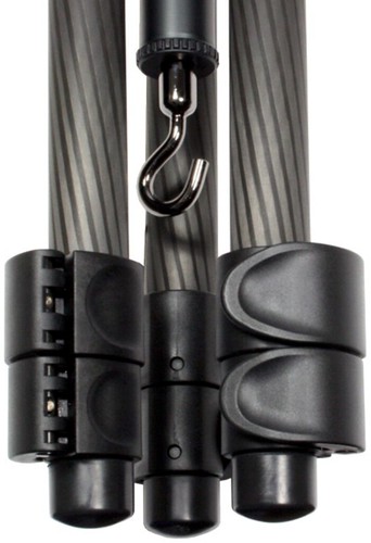
The scope got a good workout in its first real live fire exercise and was doing well. But about two thirds of the way out to what would be the extremity of that afternoon's excursion I started on a setup and immediately noted that that the rubber foot from one of the legs was missing.
And there was no way in hell I was gonna use that new toy minus that protective component in that dry soil, sand, gravel environment.
But there was also no way in hell the foot wouldn't be in one of the relevant stowage bags in the back of the SUV 'cause, although Xavier had been helping me with setups and breakdowns, it would've been inconceivable that either one of us would've missed that issue going through the drill. But... Nowhere to be found.
The better part of twelve hundred bucks worth of carbon tripod and head neutralized shortly into its first real drill by failure to adequately glue a fifty cent cap into place. Nice job, Swarovski.
But I had another CT101 tripod with me and was able to swap the center column / head assemblies and get back in business.
I think it was in the immediate vicinity of the Safety Sound Bridge that the most adorable Harbor Seal pup was flaked out on his back on a substantial snow drift running down to the water attracting a lot of activity. Couldn't have weighed more than forty pounds and wasn't the slightest bit concerned with any of the humans within real easy striking range. I so wanted to pick him up and take him home with me.
I think we turned around shortly after the road turns north, briefly becomes the Bonanza Bridge, continues north and northeast to Council. I'd picked a landmark to alert me to start looking for the stop at which Tripod 1 had last been known to be intact but failed to find it, the stop, the missing foot. But about a day or so later I got access to the back of the SUV at a point at which it wasn't partially loaded with gear and retrieved the foot from a well into which a pair of extra seats folded. Popped it back on, made a note to be extra careful with it, brought myself back up to full complement for the rest of the trip.
The Aurora Inn is situated on the north side of the coast road and our room faced Norton Sound, SSW, a lot of Almost Land of the Midnight Sun sunlight. A wee bit over 143 miles south of the Arctic Circle. And it tended to be a bit on the sweltering side minus open windows and closed curtains.
We had our dinners at Milano's about a 400 yard walk towards the harbor. I think it was the first night we ate with Xavier - Quito, Spanish accent - for company and talked about trips we'd taken and he'd led in the tropics - Belize, Trinidad/Tobago, the Pantanal and the stuff we'd seen. What with all the sleep deprivation, jet lag, physical exhaustion, stress my IQ was down about forty percent or more for most of the duration. At some point late in the conversation for several seconds I had absolutely no idea where I was. I thought I was in the tropics somewhere but couldn't think where or how I'd gotten there. It took some seconds of brain reboot to figure out that I was in Nome on Alaska's Seward Peninsula a bit over two degrees shy of the Arctic Circle and not somewhere in Venezuela.


