More later, but for now I just wanted to say that I was still in Yellowstone when the storm hit and have not yet returned to Houston. I was supposed to fly back today but will instead be staying with my dad in Louisiana until it's possible to return. No idea what the status of my apartment is, but I'm safe at least.Tad Eareckson wrote:And speaking of which, I sure hope Zack's still above flood level in the current horrendous Houston/Harvey situation.
birds
Re: birds
-
Tad Eareckson

- Posts: 9149
- Joined: 2010/11/25 03:48:55 UTC
Re: birds
Thanks Zack, relieved to hear it. Been thinking about ya about once every twenty minutes of every waking hour - and I'm not doing enough sleep to be worth mentioning. Hoping that the material chunk of your life comes through in reasonable shape.
Looks like Mother Nature didn't get the word about helping to make America great again. Massively depressing, not to mention frightening, even if one doesn't have any personal connections being affected.
Looks like Mother Nature didn't get the word about helping to make America great again. Massively depressing, not to mention frightening, even if one doesn't have any personal connections being affected.
-
Steve Davy
- Posts: 1338
- Joined: 2011/07/18 10:37:38 UTC
Re: birds
What a relief it is to read that you're not in the middle of that nightmare situation. Thanks big time for checking in here, Zack.
-
Tad Eareckson
- Posts: 9149
- Joined: 2010/11/25 03:48:55 UTC
Re: birds
My brother called me up midday Saturday and I think we talked for a couple hours. A while back when I was gearing up for this eclipse I'd said to him, "I hate you." His response, "Yeah, I know."
On 1970/03/07 I was 16, he was 13, sister was pushing 10. As I've said before, they were down with both parents taking entrance exams for Norfolk Academy while I was left in Annapolis to take the stupid fucking PSAT test in the morning.
He'd never before Saturday said much of anything about the eclipse beyond that he'd seen it 'cause he knew what I'd missed and what our parents had done to me.
Had talked with my sister Wednesday evening and discussed 1970/03/07. She said that they'd stopped on the Chesapeake Bay Bridge Tunnel to watch the total - which sounded bizarre. There ARE four artificial islands - a pair for both tunnels - with tons of parking where that would've been totally doable - but she was insistent that they just stopped on the bridge.
Ran that by my brother... No fuckin' way, we were in fields. Which would have to have meant the first 58.6 odometer miles of US 13 on the Delmarva Peninsula to get anywhere from two and a half minutes down to a millisecond blink of totality. From the Norfolk Academy parking lot its two turns, 5.7 miles, ten minutes and thirteen seconds to the end of land for a while and there ain't no fields en route.
And my sister's memory is generally rubbish anyway.
And it was getting dark and my brother had to ask my father if it would be OK if they pulled over for a minute or so to watch the total. Un fucking believable. US Navy Captain and rabid sailboat racer. And my mother never knew the difference between a solar and lunar or cared.
Meanwhile, back in my neighborhood east of Annapolis, everyone and his dog were going batshit crazy with homemade pinhole cameras for 2:31:34.3 hours of partial up to a still blinding 95.8 percent.
And meanwhile, back at the middle of the fifty yard line at the Norfolk Academy football field, 15.5 miles on the NW side from Centerline:
1970/03/07
36°52'31.06" N 076°11'34.71" W
36.87530°, -76.19298°
2:37.6 (total solar eclipse)
2:34.5 (lunar limb corrected)
Umbral depth - 62.19%
Umbral depth - 25.0 km (15.5 mi)
Path width - 32.3 km (82.2 mi)
Obscuration - 100.00%
Magnitude at maximum - 1.01167
Moon/Sun size ratio - 1.03753
Umbral velocity - 1.014 km/s (2267 mph)
Event (ΔT=40.4s) - Altitude - Azimuth - P - V - LC
C1 - 17:17:34.9 - 47.9° - 180.6° - 227° - 04.5
C2 - 18:34:47.5 - 44.0° - 207.9° - 025° - 11.9 - +0.1 s
MX - 18:36:06.4 - 43.9° - 208.3° - 138° - 08.2
C3 - 18:37:25.1 - 43.8° - 208.7° - 250° - 04.3 - -3.0 s
C4 - 19:50:52.4 - 34.5° - 229.2° - 049° - 11.6
About 21 seconds more by doing nothing than I got for months of research and preparation, flying most of the way across a rather substantial continent, camping out on a couch for a week, renting a car, rolling at 03:30, driving four hours to the middle of some rattlesnake infested desert.
But you'd have had to have delayed your departure for a good chunk of an hour. Fuck that.
Do the unimaginable, drive to the Center of the Path where it where it starts making the jump to Nova Scotia... Ten turns, 22 miles, 48 minutes and thirteen seconds. (Although, granted, there were probably a few dozen folk that day who would've attached some value to what was going on in the sky so maybe closer to an hour.)
1970/03/07
36°45'08.85" N 075°56'48.78" W
36.75246°, -75.94688°
2:50.2 (total solar eclipse)
2:50.5 (lunar limb corrected)
Umbral depth - 100.00%
Umbral depth - 0 m (0 ft)
Path width - 132.1 km (82.1 mi)
Obscuration - 100.00%
Magnitude at maximum - 1.01876
Moon/Sun size ratio - 1.03753
Umbral velocity - 1.017 km/s (2275 mph)
Event (ΔT=40.4s) - Altitude - Azimuth - P - V - LC
C1 - 17:17:47.8 - 48.0° - 181.1° - 227° - 04.5
C2 - 18:34:54.7 - 44.0° - 208.3° - 048° - 11.2 - -0.8 s
MX - 18:36:19.9 - 43.9° - 208.8° - 138° - 08.2
C3 - 18:37:44.8 - 43.8° - 209.2° - 228° - 05.1 - -0.5 s
C4 - 19:51:04.0 - 34.4° - 229.5° - 049° - 11.6
http://www.space.com/35998-remembering-1970-solar-eclipse.html
NASA Remembers 1970 Solar 'Eclipse of the Century'
Me too. Good thing it wasn't just the 1970 Solar 'Eclipse of the Lifetime, Decade, or sumpin'.
-
Tad Eareckson
- Posts: 9149
- Joined: 2010/11/25 03:48:55 UTC
Re: birds
Rental car:
06-7135 - 11:18
http://c1.staticflickr.com/5/4366/36626702272_4358292a95_o.jpg

2017 Toyota Corolla. Blew me away.
- While running cruise control uses radar to prevent closing on a slower moving car ahead. Not perfect. Doesn't necessarily recognize that such a car may be taking an exit and clearing your path. But still...
- Automatically detects tail lights ahead and oncoming head lights and dims and high beams accordingly. Again, not perfect. But it doesn't forget to go back to high all the time like I tend to.
- No GPS. I'm sure the rental companies exclude that options so's they can rent you a unit for ten bucks a day. I brought my own with zillions of relevant waypoints meticulously punched in already so not much skin off my nose.
- Backup camera. Need to keep a soft brush handy 'cause the fine dust that we were encountering/generating all the freakin' time turns it to close to useless.
And, yeah, I know I'm probably the last person on the planet to hear about the first two capabilities.
I was really concerned about the catalytic converter fire issue - 'specially being the source of one. But with untold thousands of vehicles doing what we were in the most dangerous possible conditions I've found not a single report of an incident. I'm sure the shoulder mowing prep work didn't make things any worse though.
A single Turkey Vulture for the trip - in some hills just south of Helena in which I dumped Nephew for a descent on a mountain bike trail.
Zero Kestrels in the many hundreds of miles subsequent to the family of six after getting back down from the cabin.
Curled index finger to make pinhole camera and project upside down eclipse image on sand.
http://www.abovetopsecret.com/forum/thread843144/pg1
The odd and beautiful pinhole effect - pictures and explanations., page 1
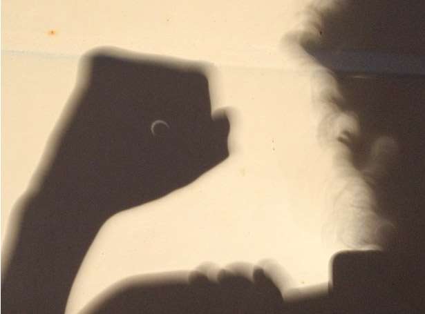
No trees around to do the trick for us.
I hope/think this:
http://www.reddit.com/r/space/comments/6wdbjx/this_is_what_the_highest_point_in_the_path_of/
This is what the highest point in the path of totality looked like to the naked eye. Borah Peak, Idaho 12,500 feet : space
http://i.redd.it/41cdpyttabiz.jpg
http://c2.staticflickr.com/8/7431/14062934261_9419b9706d_o.jpg
is real.
Borah Peak is both higher and lower than what "scottsusername" says it is. 12662 feet - which one would think one who went to the effort of climbing it would know. And most assuredly not the highest point in the Path. Let's try these from the next state down-eclipse and in the Path:
13020 - Mount Whitecap
13020 - Bow Mountain
13052 - Harrower Peak
13062 - South Downs Mountain
13114 - Klondike Peak
13115 - Henderson Peak
13155 - Split Mountain
13155 - Desolation Peak
13185 - East Twin Peak
13198 - Brown Cliffs North
13205 - American Legion Peak
13220 - Spearhead Pinnacle
13258 - The Sphinx
13265 - Mount Koven
13349 - Downs Mountain
13365 - Pinnacle Ridge
13450 - Flagstone Peak
13460 - Sunbeam Peak
13468 - Mount Febbas
13494 - Bastion Peak
13502 - Mount Woodrow Wilson
13517 - Jackson Peak
13569 - Mount Sacagawea
13599 - Doublet Peak
13620 - Turret Peak
13620 - Mount Helen
13722 - Mount Warren
13745 - Fremont Peak
13770 - Grand Teton
13804 - Gannett Peak
Borah's just both the highest point in the Path in Idaho and in Idaho. And after you get down-eclipse from Wyoming there's not much left in the way of highest point contenders. (Kinda hard to get BELOW Borah Peak level in the Wind River Range.)
Max at Borah Peak is at 11:31:13.1 MDT - 1:32.2 minutes before E09 gets it. And the azimuth is 130.0 degrees
E09 is on a 108 degree heading from Borah so drop straight down from the eclipse to the horizon and look 22 degrees to the left/north and 52.0 miles out to find us.
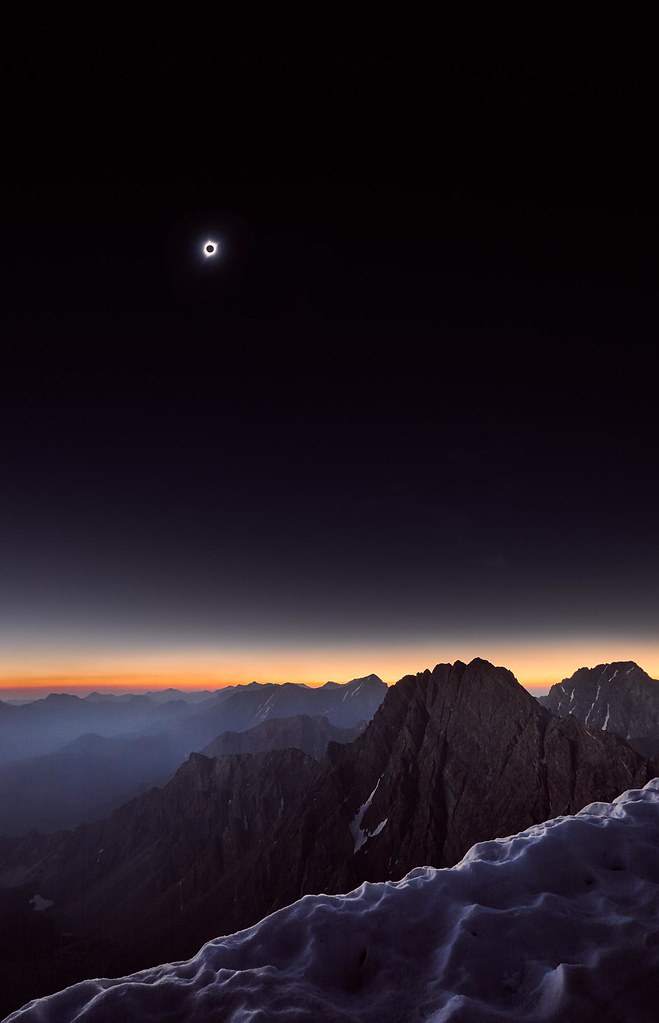
This one:
http://www.youtube.com/watch?v=qvBRZvVDQ3k
from the undisputed global high point of the Path - Gannett Peak, 13804 feet - is 16.5 miles from Centerline on the south side and 165 miles down-eclipse from E09 is real. A wee bit shy of 2:03 minutes of totality (which agrees nicely with what we see in the video) maxing at 11:37:56.0 MDT, 5:10.7 minutes behind us.
Note the razor sharp shadows in the final several minutes prior to totality.
Pretty cool vantage point, the mountaintoppers got to experience stuff (like seeing the shadow clearly advancing across the surface) of which we plains people only got tastes but::
- I don't think anyone up there had anything better than cardboard eclipse glasses with which to view any partial stuff.
- Probably nothing more than light, unstabilized, handheld binoculars with which to view the total.
- The video pair appears to have spent nearly all of C1-C2 making the ascent (read not enjoying the pre-total partial time) and didn't leave itself a lot of time to catch the total from the top.
Wouldn't trade my experience for theirs.
---
2019/08/06 12:00:00 UTC
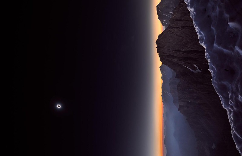
A 90 degree CCW rotation of the beautiful Borah Peak shot above which allows one higher resolution display-filling views with the laptop rotated 90 CW:
http://live.staticflickr.com/65535/48471187327_31d2bc02bb_o.png
http://live.staticflickr.com/65535/48471187327_8f07e02d56_h.jpg
http://live.staticflickr.com/65535/48471187327_0f3bd35b83_b.jpg
06-7135 - 11:18
http://c1.staticflickr.com/5/4366/36626702272_4358292a95_o.jpg
2017 Toyota Corolla. Blew me away.
- While running cruise control uses radar to prevent closing on a slower moving car ahead. Not perfect. Doesn't necessarily recognize that such a car may be taking an exit and clearing your path. But still...
- Automatically detects tail lights ahead and oncoming head lights and dims and high beams accordingly. Again, not perfect. But it doesn't forget to go back to high all the time like I tend to.
- No GPS. I'm sure the rental companies exclude that options so's they can rent you a unit for ten bucks a day. I brought my own with zillions of relevant waypoints meticulously punched in already so not much skin off my nose.
- Backup camera. Need to keep a soft brush handy 'cause the fine dust that we were encountering/generating all the freakin' time turns it to close to useless.
And, yeah, I know I'm probably the last person on the planet to hear about the first two capabilities.
I was really concerned about the catalytic converter fire issue - 'specially being the source of one. But with untold thousands of vehicles doing what we were in the most dangerous possible conditions I've found not a single report of an incident. I'm sure the shoulder mowing prep work didn't make things any worse though.
A single Turkey Vulture for the trip - in some hills just south of Helena in which I dumped Nephew for a descent on a mountain bike trail.
Zero Kestrels in the many hundreds of miles subsequent to the family of six after getting back down from the cabin.
Curled index finger to make pinhole camera and project upside down eclipse image on sand.
http://www.abovetopsecret.com/forum/thread843144/pg1
The odd and beautiful pinhole effect - pictures and explanations., page 1
No trees around to do the trick for us.
I hope/think this:
http://www.reddit.com/r/space/comments/6wdbjx/this_is_what_the_highest_point_in_the_path_of/
This is what the highest point in the path of totality looked like to the naked eye. Borah Peak, Idaho 12,500 feet : space
http://i.redd.it/41cdpyttabiz.jpg
http://c2.staticflickr.com/8/7431/14062934261_9419b9706d_o.jpg
is real.
Borah Peak is both higher and lower than what "scottsusername" says it is. 12662 feet - which one would think one who went to the effort of climbing it would know. And most assuredly not the highest point in the Path. Let's try these from the next state down-eclipse and in the Path:
13020 - Mount Whitecap
13020 - Bow Mountain
13052 - Harrower Peak
13062 - South Downs Mountain
13114 - Klondike Peak
13115 - Henderson Peak
13155 - Split Mountain
13155 - Desolation Peak
13185 - East Twin Peak
13198 - Brown Cliffs North
13205 - American Legion Peak
13220 - Spearhead Pinnacle
13258 - The Sphinx
13265 - Mount Koven
13349 - Downs Mountain
13365 - Pinnacle Ridge
13450 - Flagstone Peak
13460 - Sunbeam Peak
13468 - Mount Febbas
13494 - Bastion Peak
13502 - Mount Woodrow Wilson
13517 - Jackson Peak
13569 - Mount Sacagawea
13599 - Doublet Peak
13620 - Turret Peak
13620 - Mount Helen
13722 - Mount Warren
13745 - Fremont Peak
13770 - Grand Teton
13804 - Gannett Peak
Borah's just both the highest point in the Path in Idaho and in Idaho. And after you get down-eclipse from Wyoming there's not much left in the way of highest point contenders. (Kinda hard to get BELOW Borah Peak level in the Wind River Range.)
Max at Borah Peak is at 11:31:13.1 MDT - 1:32.2 minutes before E09 gets it. And the azimuth is 130.0 degrees
E09 is on a 108 degree heading from Borah so drop straight down from the eclipse to the horizon and look 22 degrees to the left/north and 52.0 miles out to find us.
This one:
http://www.youtube.com/watch?v=qvBRZvVDQ3k
from the undisputed global high point of the Path - Gannett Peak, 13804 feet - is 16.5 miles from Centerline on the south side and 165 miles down-eclipse from E09 is real. A wee bit shy of 2:03 minutes of totality (which agrees nicely with what we see in the video) maxing at 11:37:56.0 MDT, 5:10.7 minutes behind us.
Note the razor sharp shadows in the final several minutes prior to totality.
Pretty cool vantage point, the mountaintoppers got to experience stuff (like seeing the shadow clearly advancing across the surface) of which we plains people only got tastes but::
- I don't think anyone up there had anything better than cardboard eclipse glasses with which to view any partial stuff.
- Probably nothing more than light, unstabilized, handheld binoculars with which to view the total.
- The video pair appears to have spent nearly all of C1-C2 making the ascent (read not enjoying the pre-total partial time) and didn't leave itself a lot of time to catch the total from the top.
Wouldn't trade my experience for theirs.
---
2019/08/06 12:00:00 UTC
A 90 degree CCW rotation of the beautiful Borah Peak shot above which allows one higher resolution display-filling views with the laptop rotated 90 CW:
http://live.staticflickr.com/65535/48471187327_31d2bc02bb_o.png
http://live.staticflickr.com/65535/48471187327_8f07e02d56_h.jpg
http://live.staticflickr.com/65535/48471187327_0f3bd35b83_b.jpg
-
Tad Eareckson
- Posts: 9149
- Joined: 2010/11/25 03:48:55 UTC
Re: birds
http://en.wikipedia.org/wiki/Solar_eclipse_of_August_21,_2017
Solar eclipse of August 21, 2017 - Wikipedia
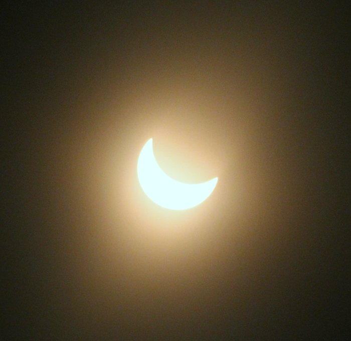
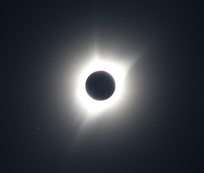
http://c1.staticflickr.com/5/4341/35982955973_82e2a57f61_o.jpg
07-7144
http://c1.staticflickr.com/5/4373/36626720622_825d4024f7_o.jpg
11-7161c
http://c1.staticflickr.com/5/4392/36798305975_9808dd3c27_o.png

Wouldn't taking "anti-snake bite antidote" be a lot like doing nothing? 'Cept a lot cheaper, more convenient, with fewer adverse side effects?
http://www.youtube.com/watch?v=N4vf8N6GpdM
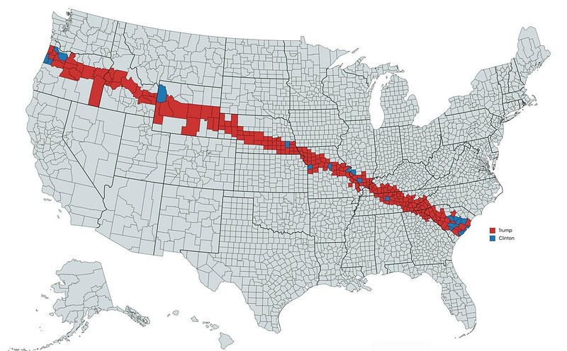
The 2017 solar eclipse is coming - to Trump Country - The Boston Globe
http://c.o0bg.com/rf/image_1920w/Boston/2011-2020/2017/08/01/BostonGlobe.com/Metro/Images/2a3715d3-f67c-49d7-86c9-07c07395b3f4-9836.png
Solar eclipse of August 21, 2017 - Wikipedia
04-7114Planning
Oregon deployed six National Guard aircraft and 150 soldiers because the influx of visitors coincided with the state's fire season. Hospital staffing, and supplies of blood and anti-snake bite antidote, were augmented along the totality line.
http://c1.staticflickr.com/5/4341/35982955973_82e2a57f61_o.jpg
07-7144
http://c1.staticflickr.com/5/4373/36626720622_825d4024f7_o.jpg
11-7161c
http://c1.staticflickr.com/5/4392/36798305975_9808dd3c27_o.png
Wouldn't taking "anti-snake bite antidote" be a lot like doing nothing? 'Cept a lot cheaper, more convenient, with fewer adverse side effects?
http://www.youtube.com/watch?v=N4vf8N6GpdM
http://www.bostonglobe.com/metro/2017/08/01/the-solar-eclipse-coming-trump-country/Ldd7MhDroW1cdYCwCBoxbO/story.htmlNo, I assure you there haven't been no Jews in this village.
The 2017 solar eclipse is coming - to Trump Country - The Boston Globe
http://c.o0bg.com/rf/image_1920w/Boston/2011-2020/2017/08/01/BostonGlobe.com/Metro/Images/2a3715d3-f67c-49d7-86c9-07c07395b3f4-9836.png
-
Tad Eareckson
- Posts: 9149
- Joined: 2010/11/25 03:48:55 UTC
Re: birds
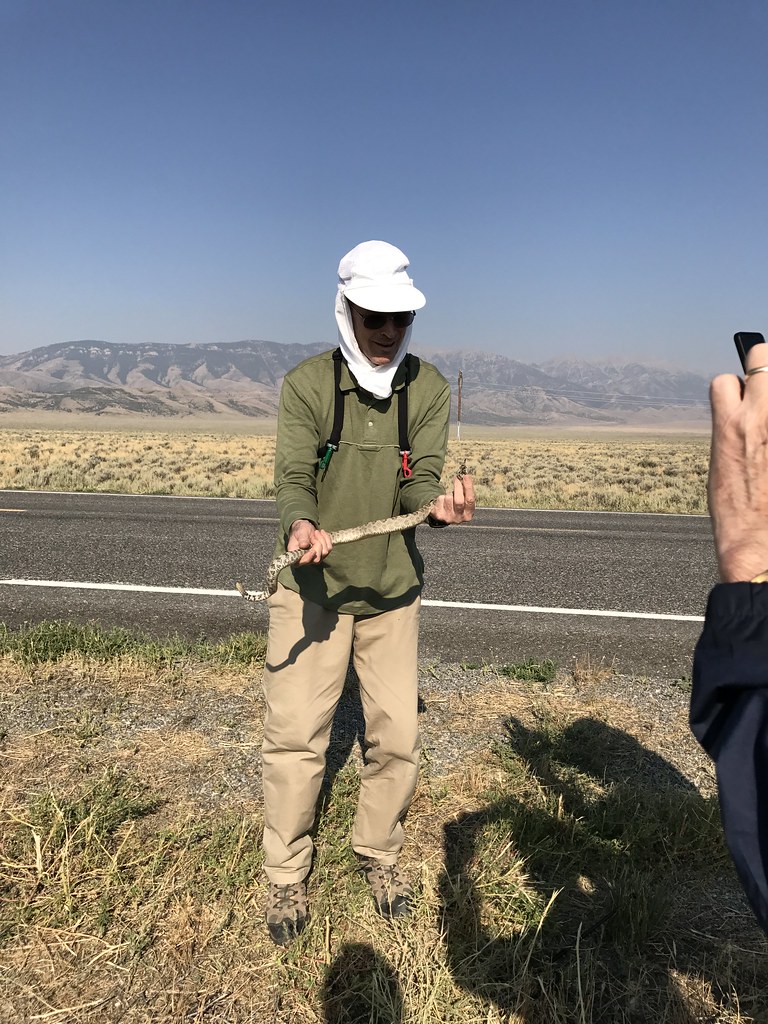
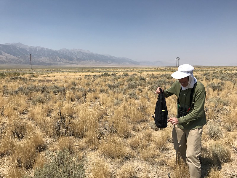
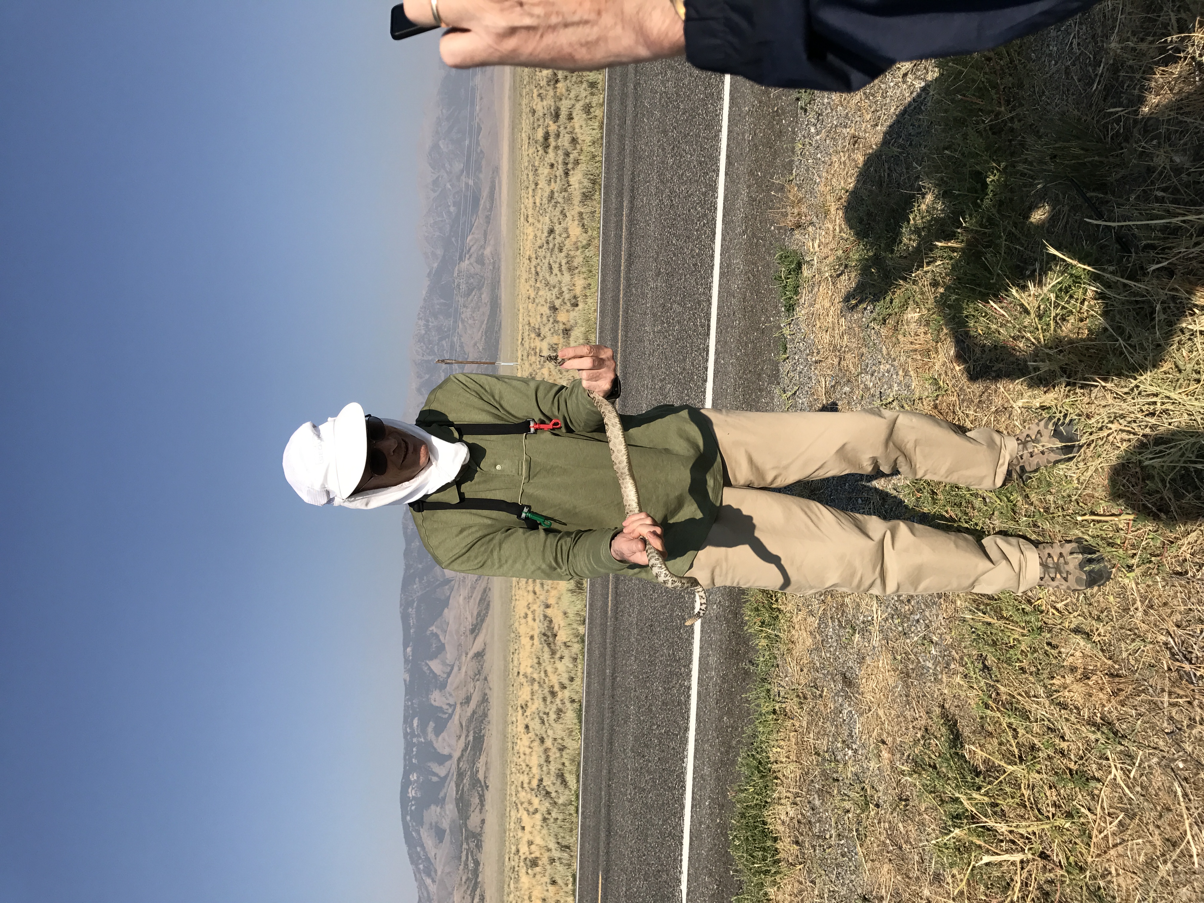
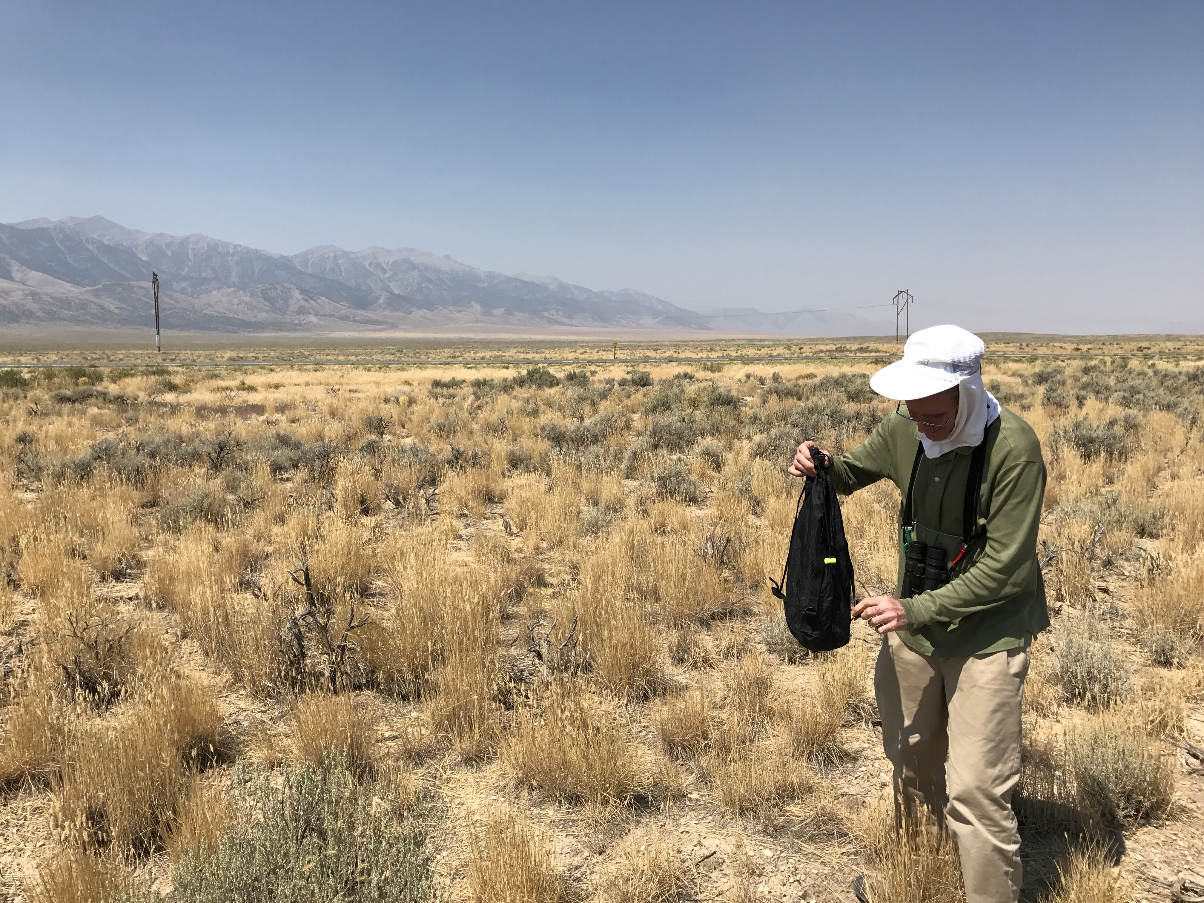
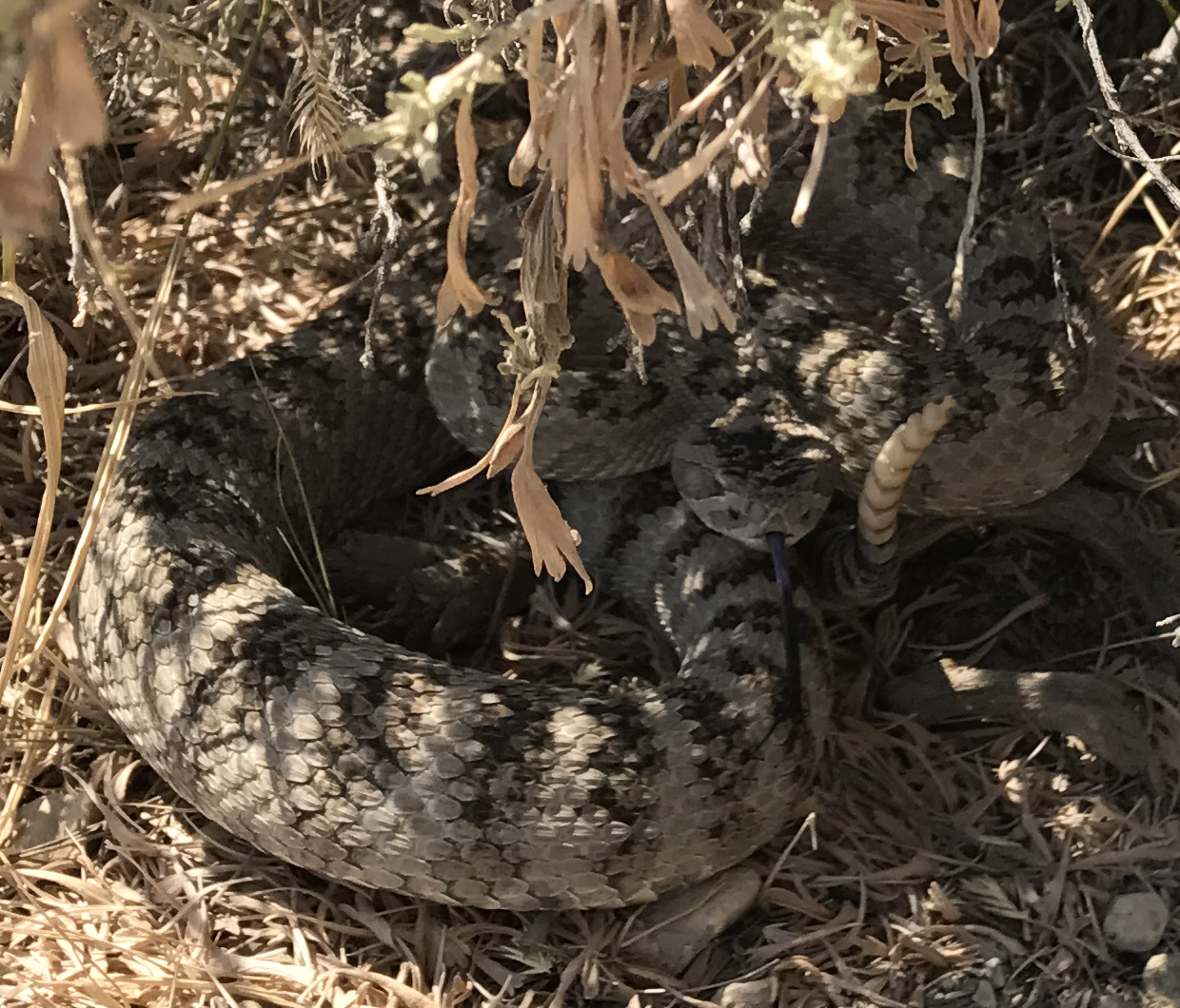
Rethinking the rattler situation a bit...
I've been saying that he went under the car for shade. I'm calling that wrong. When I first encountered him he was close to the sunny side of the car, the car was pretty much broadside to the sun, the sun was under 29 degrees up from the horizon, he was in full sunlight, and the temperature was not yet the least bit up from comfortable. This would've been even more the case when he first made his presence known. He was just using the car for cover. (Remember that Golden Eagle and swarm of Redtails we encountered on the way in?)
As to what flavor the damn thing was... The herpetologist folk keep screwing around with species and subspecies. I didn't know what they had in that neck of the "woods" and was first guessing Prairie - like the one I'd bagged in North Dakota, Standing Rock Indian Reservation in 1985 - which had been dubbed the Crotalus viridis viridis subspecies of the Western Rattler.
The next rattler I bagged was in the Cascades and at the time he was Crotalus viridis oreganus - the Northern Pacific subspecies of the Western Rattler.
The Prairie extends into west central Idaho but not quite into the Snake River Plain.
The Northern Pacific Rattler is now a separate species, Crotalus oreganus, and the beast I bagged at E09 was lutosus - Great Basin Rattler. No brainer given the range maps and habitat.
The iPhone app Peter was using - and we were hearing - to get alerts of critical phases:
http://www.solareclipsetimer.com
Solar Eclipse Timer App
The developer's video on how to shoot an eclipse properly:
http://www.youtube.com/watch?v=74gXw0aKUhk
Excellent illustration of why someone who's not thoroughly geeked out and drilled shouldn't be wasting his prime time trying to shoot pictures.
Speaking of iPhones... The cell networks were supposed to have been overwhelmed out there in Path Territory but Peter was talking to the wife back in Salt Lake City at frequent intervals as things were ramping up and having no problems.
Truth in advertising... Post Eclipse Depression.
I'd spent decades with 2017/08/21 on the calendar; months of research, equipping, planning, prep; days of staying glued to weather and traffic predictions, planning for alternates, considering worst case scenarios; hours of moving into position and setting up the observation station and neutralizing deadly reptile threats.
And constant fear almost down to the wire - knowing that all that planning, effort, expense could be instantly neutralized by something like an illness, driving mishap, guy with a badge, cumulus cloud.
All this physical and psychological stress then everything goes like clockwork and you get this incredible indescribable experience you soon won't be able to believe was real.
Then there's a wind-down when you say goodbye to all these great-friends-for-life whom you'll never see again and the density of shared-experience eclipsees starts dropping off fast. (Across-the-street neighbor watched it total from a boat (sail, I believe he said) just off Fort Sumpter to the NW. Didn't get wiped out by the clouds but they did affect the quality of the view.)
Then back home, empty cage, isolation, crash, massive paralyzing depression. Then ya do all this research to better understand what you've just seen and experienced and post about it in no small part to serve as a distraction.
Wonder how Zack's doing with no home to go back to - in the short term at a minimum - and the Plan B having caught some of the same flak that necessitated the Plan B in the first place.
I've been saying that he went under the car for shade. I'm calling that wrong. When I first encountered him he was close to the sunny side of the car, the car was pretty much broadside to the sun, the sun was under 29 degrees up from the horizon, he was in full sunlight, and the temperature was not yet the least bit up from comfortable. This would've been even more the case when he first made his presence known. He was just using the car for cover. (Remember that Golden Eagle and swarm of Redtails we encountered on the way in?)
As to what flavor the damn thing was... The herpetologist folk keep screwing around with species and subspecies. I didn't know what they had in that neck of the "woods" and was first guessing Prairie - like the one I'd bagged in North Dakota, Standing Rock Indian Reservation in 1985 - which had been dubbed the Crotalus viridis viridis subspecies of the Western Rattler.
The next rattler I bagged was in the Cascades and at the time he was Crotalus viridis oreganus - the Northern Pacific subspecies of the Western Rattler.
The Prairie extends into west central Idaho but not quite into the Snake River Plain.
The Northern Pacific Rattler is now a separate species, Crotalus oreganus, and the beast I bagged at E09 was lutosus - Great Basin Rattler. No brainer given the range maps and habitat.
The iPhone app Peter was using - and we were hearing - to get alerts of critical phases:
http://www.solareclipsetimer.com
Solar Eclipse Timer App
Wrong. It was the app that tipped everybody off. (Damn I wish we'd had a sheet down.)Nephew HAPPENED to notice the effect on an area of open sand just behind the tripod and called attention to it.
The developer's video on how to shoot an eclipse properly:
http://www.youtube.com/watch?v=74gXw0aKUhk
Excellent illustration of why someone who's not thoroughly geeked out and drilled shouldn't be wasting his prime time trying to shoot pictures.
Speaking of iPhones... The cell networks were supposed to have been overwhelmed out there in Path Territory but Peter was talking to the wife back in Salt Lake City at frequent intervals as things were ramping up and having no problems.
Truth in advertising... Post Eclipse Depression.
I'd spent decades with 2017/08/21 on the calendar; months of research, equipping, planning, prep; days of staying glued to weather and traffic predictions, planning for alternates, considering worst case scenarios; hours of moving into position and setting up the observation station and neutralizing deadly reptile threats.
And constant fear almost down to the wire - knowing that all that planning, effort, expense could be instantly neutralized by something like an illness, driving mishap, guy with a badge, cumulus cloud.
All this physical and psychological stress then everything goes like clockwork and you get this incredible indescribable experience you soon won't be able to believe was real.
Then there's a wind-down when you say goodbye to all these great-friends-for-life whom you'll never see again and the density of shared-experience eclipsees starts dropping off fast. (Across-the-street neighbor watched it total from a boat (sail, I believe he said) just off Fort Sumpter to the NW. Didn't get wiped out by the clouds but they did affect the quality of the view.)
Then back home, empty cage, isolation, crash, massive paralyzing depression. Then ya do all this research to better understand what you've just seen and experienced and post about it in no small part to serve as a distraction.
Wonder how Zack's doing with no home to go back to - in the short term at a minimum - and the Plan B having caught some of the same flak that necessitated the Plan B in the first place.
Re: birds
Just fine, actually. Lafayette (Plan B) ended up between rain bands when the storm moved through and got almost no rain (some areas east of it experienced flooding).Tad Eareckson wrote:Wonder how Zack's doing with no home to go back to - in the short term at a minimum - and the Plan B having caught some of the same flak that necessitated the Plan B in the first place.
I was finally able to get in touch with my apartment complex Wednesday and confirmed that other than a few roof leaks the property was fine. I did look at floodplains when I originally chose the location, but I was still concerned given the unprecedented rainfall we received.
By Thursday Houston was sunny (with low overcast but no rain in Lafayette). Although many roads between me and home were still flooded, TxDOT had them well marked, and I was able to chart a course that got me home without any drama (approaching the city from the north). Looking around the apartment complex you wouldn't know anything unusual happened. My unit was just as I left it.
I appreciate the concern (Steve too) and apologize for not being particularly timely in giving updates. I've had limited time as I've been working remotely; our office is undamaged and we return Tuesday.
Many people lost everything in this storm, and I don't mean to make light of their plights. However, the media is naturally focusing on the devestation, and this can give a skewed perspective of reality. I'm not particularly well-connected, but of the couple dozen or so Houstonians I've been in contact with since the storm, no one's experienced worse than being shut in for a few days and maybe a brief power outage.
I enjoyed the detailed account of your trip, Tad. I'll try and post some of my own experiences this weekend, but don't expect anything approaching yours in length. =)
-
Tad Eareckson
- Posts: 9149
- Joined: 2010/11/25 03:48:55 UTC
Re: birds
Amazing. I'da thunk that with biblical dwarfing rainfall like that one would've needed something on the order of a land based oil drilling platform to get away that unscathed.
Noticed this place:
http://vimeo.com/16572582
password - red
2-112
http://c2.staticflickr.com/8/7600/28811055456_925c8abb66_o.png
5-229
http://c1.staticflickr.com/9/8564/28811053566_3c689edfbd_o.png

9-524
http://c1.staticflickr.com/9/8566/28811050166_ca54ee1ed3_o.png
making the national news recently. For those of you nonlocals who haven't played around with Google Earth for the site that's the outflow from Barker Dam spilling out and under Addicks-Howell Road towards the center of town in the far right corner of the last frame.
We in the Baltimore area have been getting fairly heavily soaked by what's left of Harvey today. (Small continent.)
http://www.kitestrings.org/post10430.html#p10430
prior to this one we've picked up 453 hits for 27 posts - close to seventeen hits per post. Not bad for Kite Strings.
Yesterday blew two bucks on the Solar Eclipse Timer for the iPhone just to install it, play with it, see how it works. Pretty cool. Also blew nine bucks on GPS Coordinate Converter from Aviation Mobile Apps as the GPS Converter freebie from Gordon Telepun didn't seem to actually exist and something equivalent might prove necessary or at least useful.
And remember?:
http://www.kitestrings.org/post10368.html#p10368
http://xjubier.free.fr/en/site_pages/SolarEclipsesGoogleMaps.html
Solar Eclipses - Interactive Google Maps - Xavier Jubier
http://c1.staticflickr.com/5/4339/36812939822_cd2d6ef918_o.png
Crap. (The waste of time, not the result.)
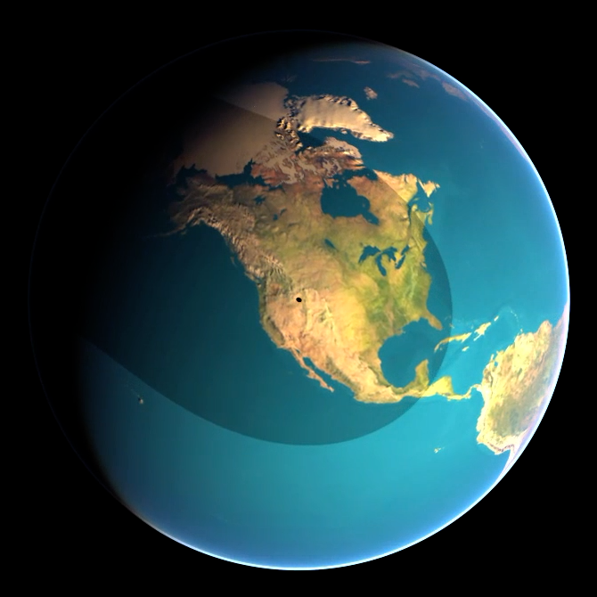
Do the download, open in Google Earth, go nuts rotating the planet around north/south/east/west for - if you're as slow as I am - a much better understanding of the issues involved in a shadow cast on a big sphere which is spinning on a cocked axis while orbiting around the distant light source and having the smallish shadow casting sphere orbit around it.
Also check out this BEAUTIFUL video:
http://xjubier.free.fr/en/site_pages/solar_eclipses/TSE_20170821_pg01.html
United States of America - Total Solar Eclipse of 2017 August 21 - Xavier Jubier
http://xjubier.free.fr/site_movies/TSE_2017_Simulation_1024x768.mp4
of the event. Can't embed it, unfortunately, but here's a still of it blacking out E09 14.7 seconds past max with another 53.7 seconds to go before the dreaded C3 mark.
Solar Eclipse Maestro (Xavier M. Jubier)
2017/08/21 17:33 UT
If anyone else wants a snapshot of the max relevant to a particular viewing station (Dubois, Wyoming for example) do lemme know.
The several dozen individuals so far known who lost their lives, however... Not so much. (Don't imagine we're gonna see much of a drop in the area suicide rate in the coming months either.)2017/08/29
This is historic. It's epic, what happened, but you know what - it happened in Texas and Texas can handle anything.
Noticed this place:
http://vimeo.com/16572582
password - red
2-112
http://c2.staticflickr.com/8/7600/28811055456_925c8abb66_o.png
5-229
http://c1.staticflickr.com/9/8564/28811053566_3c689edfbd_o.png
9-524
http://c1.staticflickr.com/9/8566/28811050166_ca54ee1ed3_o.png
making the national news recently. For those of you nonlocals who haven't played around with Google Earth for the site that's the outflow from Barker Dam spilling out and under Addicks-Howell Road towards the center of town in the far right corner of the last frame.
We in the Baltimore area have been getting fairly heavily soaked by what's left of Harvey today. (Small continent.)
Thanks. Hoping one didn't need to be a chaser - in about the same neck of the woods no less - to get something out of it. In the unbroken string in this thread starting 2017/08/10 14:31:13 UTC:I enjoyed the detailed account of your trip, Tad.
http://www.kitestrings.org/post10430.html#p10430
prior to this one we've picked up 453 hits for 27 posts - close to seventeen hits per post. Not bad for Kite Strings.
I'll be delighted with anything you can contribute. No-brainer that you at least got a completely unobstructed view from C1 through C4.I'll try and post some of my own experiences this weekend, but don't expect anything approaching yours in length. =)
Yesterday blew two bucks on the Solar Eclipse Timer for the iPhone just to install it, play with it, see how it works. Pretty cool. Also blew nine bucks on GPS Coordinate Converter from Aviation Mobile Apps as the GPS Converter freebie from Gordon Telepun didn't seem to actually exist and something equivalent might prove necessary or at least useful.
And remember?:
http://www.kitestrings.org/post10368.html#p10368
http://xjubier.free.fr/en/site_pages/SolarEclipsesGoogleMaps.html
Solar Eclipses - Interactive Google Maps - Xavier Jubier
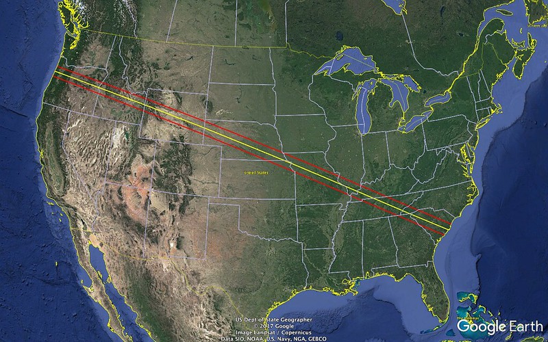
I killed a day creating a chintzy knockoff of just the Path of Totality with its Centerline from coast to coast. Looks like:If you prefer to use Google Earth, available under MacOS X, Windows and Linux, you can download the Google Earth files (kml, kmz) for each eclipses.
http://c1.staticflickr.com/5/4339/36812939822_cd2d6ef918_o.png
Crap. (The waste of time, not the result.)
Do the download, open in Google Earth, go nuts rotating the planet around north/south/east/west for - if you're as slow as I am - a much better understanding of the issues involved in a shadow cast on a big sphere which is spinning on a cocked axis while orbiting around the distant light source and having the smallish shadow casting sphere orbit around it.
Also check out this BEAUTIFUL video:
http://xjubier.free.fr/en/site_pages/solar_eclipses/TSE_20170821_pg01.html
United States of America - Total Solar Eclipse of 2017 August 21 - Xavier Jubier
http://xjubier.free.fr/site_movies/TSE_2017_Simulation_1024x768.mp4
of the event. Can't embed it, unfortunately, but here's a still of it blacking out E09 14.7 seconds past max with another 53.7 seconds to go before the dreaded C3 mark.
Solar Eclipse Maestro (Xavier M. Jubier)
2017/08/21 17:33 UT
If anyone else wants a snapshot of the max relevant to a particular viewing station (Dubois, Wyoming for example) do lemme know.
Re: birds
I don't know where you learned to handle snakes like that, Tad, but you sound like you knew what you were doing, so I'll resist the temptation to label you 'nuts'. =) I'm glad it worked out for all concerned. I'd have been in the "won't get within striking range times twenty" camp...
In any event, it sounds like all of your preparation paid off. I wasn't nearly as prepared and it didn't go quite so smoothly for me, but it worked out well enough in the end.
On the morning of the 21st I left my cabin in Yellowstone at 5:00 AM and soon found myself also part of a southbound procession. Traffic still flowed smoothly however so it didn't cause any delays, and once I turned east to leave Grand Teton National Park I largely had the road to myself. I'm pretty sure most people staying in Yellowstone were headed to viewing areas in Grand Teton or Jackson, but I had concerns about crowds and clouds from the mountains.
Like you, I had several waypoints in my GPS, and given the lack of traffic punched in my first choice at Union Pass in Shoshone National Forest. Unfortunately, my GPS picked the shortest route to the waypoint, which in this case was far from the easiest. After a few bone-jarring miles on an unmaintained road I reached a muddy impasse and had to resign myself to the fact that I wasn't getting any further. Not wanting to risk the time loss in going all the way back and finding another route or viewing location, I just turned around and pulled into a clearing in the trees a short ways down. The sun was high enough that it would be easily visible, and there wasn't a cloud in the sky. I wouldn't get a good view of the horizon, but this was good enough for me.
My dad came with me on this trip. Joining us in the clearing were four backpackers from Colorado. They had diverted to this area due to a threat of clouds at their first choice further east but wanted to avoid the crowds at Union Pass. No 'heavy artillery' but they did have some homemade stuff including a binocular projector.
As for us, all I had were some plastic eclipse glasses and cheap unfiltered 7x50 binoculars for totality. My dad had solar filters for his binoculars and SLR camera. My thinking: if I wanted to observe solar features, I could do that any day. The main show for me was totality, which I expected would be best experienced with the naked eye (though I didn't realize Baily's Beads would only be visible with magnification).
I noticed temperature dropping probably 20 minutes before totality, even before there was a noticeable drop in daylight. Our elevation was somewhere around 9,000' and by the time things were getting noticeably darker I had to put on my heavy jacket.
I had no app to announce phases, but none was necessary. I was transfixed on the sun in the final moments, watching through my glasses as the remaining sliver of orange shrank from both ends before my eyes. At the same time, my peripheral vision took in the darkness descending over the forest around me. Then, the sliver was gone, and the glasses came off.
Two minutes and twenty seconds does seem like a long time watching a clock, but it was over far too soon. A spark of light appeared at the edge of the black hole, I put my glasses back on, and the shadow quickly lifted over the forest. It was only some time after that I realized I was so mesmerized by the sight I never once touched the binoculars around my neck.
We brought sandwich material and enjoyed a picnic lunch as we watched the remainder of partiality.
Here are a couple of pics my dad snapped. He's far from a professional but I thought they came out alright.
While the eclipse took the cake in terms of amazing things I saw on this trip, Yellowstone was a great experience as well. While the thermal features stood out the most to me (I really enjoyed learning about how life, from microbes to bison, has adapted to take advantage of them), there was some great scenery (especially the canyon), innumerable waterfalls, diverse hiking, and some decent wildlife sightings (though no bears, moose, or wolves).
Where specifically were you looking for grizzlies?
I hit the Beaver Ponds trail from Mammoth (which goes into Montana very close to Gardiner) at 7:00 AM Friday (8/25) hoping to catch something good but all I got were some ducks (Ruddy, I believe). Incidentally, I was able to pick up a cell signal when we reached an overlook of Gardiner along the trail, one of the few times I had reception on this trip. It was only then that I learned about Harvey (less than a day before landfall).
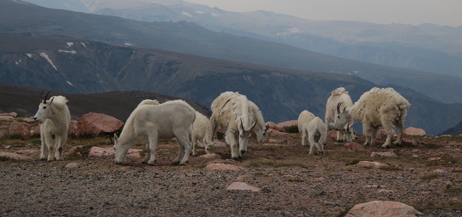
Despite going on several day hikes, my best wildlife sightings were just off the road. We encountered a herd of mountain goats on our way in via Beartooth Pass, although there wasn't any place to pull over to observe them. My dad neverthless got a shot through the window:
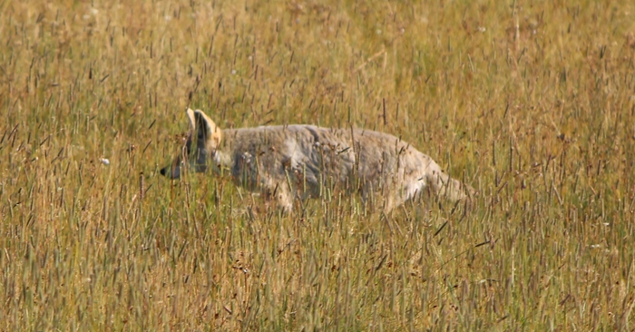
Then there was the coyote hunting something in a meadow just off the road:
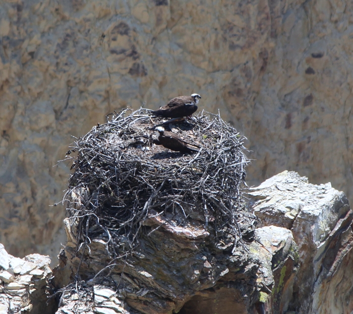
We saw a few Ospreys, including this nest in the canyon:
Also near the river were a pair of Gray Jays (again, I think...) that were surprisingly curious about us considering this is one of the least visited areas of the park.
Other than that, lots of geese, ravens, pelicans, a couple of grouse, a few Redtails, mule deer, and, of course, the ubiquitous bison.
Now to edit 30 GB worth of video...
In any event, it sounds like all of your preparation paid off. I wasn't nearly as prepared and it didn't go quite so smoothly for me, but it worked out well enough in the end.
On the morning of the 21st I left my cabin in Yellowstone at 5:00 AM and soon found myself also part of a southbound procession. Traffic still flowed smoothly however so it didn't cause any delays, and once I turned east to leave Grand Teton National Park I largely had the road to myself. I'm pretty sure most people staying in Yellowstone were headed to viewing areas in Grand Teton or Jackson, but I had concerns about crowds and clouds from the mountains.
Like you, I had several waypoints in my GPS, and given the lack of traffic punched in my first choice at Union Pass in Shoshone National Forest. Unfortunately, my GPS picked the shortest route to the waypoint, which in this case was far from the easiest. After a few bone-jarring miles on an unmaintained road I reached a muddy impasse and had to resign myself to the fact that I wasn't getting any further. Not wanting to risk the time loss in going all the way back and finding another route or viewing location, I just turned around and pulled into a clearing in the trees a short ways down. The sun was high enough that it would be easily visible, and there wasn't a cloud in the sky. I wouldn't get a good view of the horizon, but this was good enough for me.
Not so much a no-brainer with me at the helm. =) That's what I get for relying too much on technology...Tad Eareckson wrote:No brainer that you at least got a completely unobstructed view from C1 through C4.
My dad came with me on this trip. Joining us in the clearing were four backpackers from Colorado. They had diverted to this area due to a threat of clouds at their first choice further east but wanted to avoid the crowds at Union Pass. No 'heavy artillery' but they did have some homemade stuff including a binocular projector.
As for us, all I had were some plastic eclipse glasses and cheap unfiltered 7x50 binoculars for totality. My dad had solar filters for his binoculars and SLR camera. My thinking: if I wanted to observe solar features, I could do that any day. The main show for me was totality, which I expected would be best experienced with the naked eye (though I didn't realize Baily's Beads would only be visible with magnification).
I noticed temperature dropping probably 20 minutes before totality, even before there was a noticeable drop in daylight. Our elevation was somewhere around 9,000' and by the time things were getting noticeably darker I had to put on my heavy jacket.
I had no app to announce phases, but none was necessary. I was transfixed on the sun in the final moments, watching through my glasses as the remaining sliver of orange shrank from both ends before my eyes. At the same time, my peripheral vision took in the darkness descending over the forest around me. Then, the sliver was gone, and the glasses came off.
I couldn't have said it better. It wasn't the sun, but it wasn't the moon; it was like some foreign celestial body hovering in the sky overhead. I let out a few hushed exclamations but mostly watched the show in silence (broken only by the sound of my dad's camera - I wasn't gonna mess with photos myself).Tad Eareckson wrote:Looking up minus magnification and protection at this black hole surrounded by a glowing white corona is the most unworldly thing you'll ever experience.
Two minutes and twenty seconds does seem like a long time watching a clock, but it was over far too soon. A spark of light appeared at the edge of the black hole, I put my glasses back on, and the shadow quickly lifted over the forest. It was only some time after that I realized I was so mesmerized by the sight I never once touched the binoculars around my neck.
We brought sandwich material and enjoyed a picnic lunch as we watched the remainder of partiality.
Here are a couple of pics my dad snapped. He's far from a professional but I thought they came out alright.
While the eclipse took the cake in terms of amazing things I saw on this trip, Yellowstone was a great experience as well. While the thermal features stood out the most to me (I really enjoyed learning about how life, from microbes to bison, has adapted to take advantage of them), there was some great scenery (especially the canyon), innumerable waterfalls, diverse hiking, and some decent wildlife sightings (though no bears, moose, or wolves).
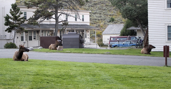
Tell me about it. I stayed three nights in Mammoth not far from Gardiner and it was the same there. This was taken not far from my cabin:Tad Eareckson wrote:In Gardiner there were Elk hanging out on the lawn behaving like petting zoo animals.
Where specifically were you looking for grizzlies?
I hit the Beaver Ponds trail from Mammoth (which goes into Montana very close to Gardiner) at 7:00 AM Friday (8/25) hoping to catch something good but all I got were some ducks (Ruddy, I believe). Incidentally, I was able to pick up a cell signal when we reached an overlook of Gardiner along the trail, one of the few times I had reception on this trip. It was only then that I learned about Harvey (less than a day before landfall).
Despite going on several day hikes, my best wildlife sightings were just off the road. We encountered a herd of mountain goats on our way in via Beartooth Pass, although there wasn't any place to pull over to observe them. My dad neverthless got a shot through the window:
Then there was the coyote hunting something in a meadow just off the road:
We saw a few Ospreys, including this nest in the canyon:
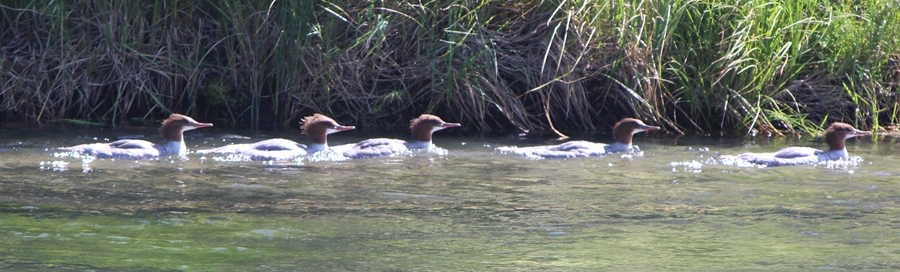
Got a few of those (I think) swimming up the Bechler River:Tad Eareckson wrote:Got a great female Common Merganser tearing down the rapids of the Sun River.
Also near the river were a pair of Gray Jays (again, I think...) that were surprisingly curious about us considering this is one of the least visited areas of the park.
Other than that, lots of geese, ravens, pelicans, a couple of grouse, a few Redtails, mule deer, and, of course, the ubiquitous bison.
Now to edit 30 GB worth of video...